Reguengo geodata
Reguengo (Portalegre) is a seat of a third-order administrative division; located in Portugal in Europe/Lisbon (GMT+1) time zone. In our database, there are 824 cities with bigger population. Compared to other cities in Portugal, 58.5% of cities are located further ↑North; 95.4% of cities are located further ←West and 95.1% of cities have lower elevation than Reguengo. Note1


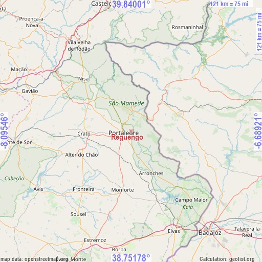
Reguengo GPS coordinates[2]
39° 17' 52.836" North, 7° 23' 32.424" West
| Map corner | latitude | longitude |
|---|---|---|
| Upper-left | 39.84001°, | -8.09546° |
| Center: | 39.29801°, | -7.39234° |
| Lower-right: | 38.75178°, | -6.68921° |
| Map W x H: | 121×121 km | = 75.2×75.2mi |
| max Lat: | 42.11337° ⇑58.5% North |
| Reguengo: | 39.29801° |
| min Lat: | ⇓41.5% South 32.6448° |
| min Long | Reguengo | max Long |
| -31.17847° | -7.39234° | -6.27308° |
| W 95.4%⇐ | ⇒4.6% E |
Elevation
Elevation of Reguengo is 604 m = 1982 ft, and this is 427 m = 1401 ft above average elevation for this country.
| Max E: |
1008 m = 3307 ft | 4.9% |
| Reguengo | 604 m 1982 ft | |
| Avg. | 177 m = 581 ft | |
Min E: |
-128 m = -420 ft | 95.1% |
See also: Portugal elevation on elevation.city.
Geographical zone
Reguengo is located in North temperate zone (between Tropic of Cancer and the Arctic Circle). Distance of this Northern Tropic circle is 1763.6 km =1095.8 mi to South.| Distance of | km | miles | from Reguengo |
|---|---|---|---|
| North Pole | 5637.5 | 3503 | to North |
| Arctic Circle | 3031.6 | 1883.7 | to North |
| Tropic Cancer | 1763.6 | 1095.8 | to South |
| Equator | 4369.5 | 2715.1 | to South |


Nearby cities:
15 places around Reguengo: (largest is in red/bold)
• Alagoa
14.4 km =8.9 mi,  299°
299°
• Alegrete
8.8 km =5.5 mi,  137°
137°
• Alter do Chão
25.5 km =15.8 mi,  244°
244°
• Arronches
21.6 km =13.4 mi,  154°
154°
• Castelo de Vide
14.3 km =8.9 mi,  337°
337°
• Fortios
9.8 km =6.1 mi,  287°
287°
• Fronteira
34.8 km =21.6 mi,  219°
219°
• Gáfete
28 km =17.4 mi, 296°
• Marvão
10.7 km =6.6 mi,  7°
7°
• Monforte
27.5 km =17.1 mi,  188°
188°
• Nisa
32.7 km =20.3 mi,  317°
317°
• Portalegre
3.4 km =2.1 mi,  262°
262°
• Póvoa e Meadas
26 km =16.2 mi, 335°
• São Julião
7.5 km =4.7 mi,  68°
68°
• Urra
7.8 km =4.8 mi,  183°
183°
Sources, notices
• [Note1] Compared only with cities in Portugal existing in our database
• [Src1] Map data: © OpenStreetMap contributors (CC-BY-SA)
• [Src2] Other city data from geonames.org with taken over terms of usage.
• [Src3] Geographical zone / Annual Mean Temperature by Robert A. Rohde @ Wikipedia
