Alfeizerão geodata
Alfeizerão (Leiria) is a populated place; located in Portugal in Europe/Lisbon (GMT+1) time zone. With population of 3,854 people, there are 534 cities with bigger population in this country. Compared to other cities in Portugal, 52.5% of cities are located further ↑North; 78.3% of cities are located further →East and 86.3% of cities have higher elevation than Alfeizerão. Note1


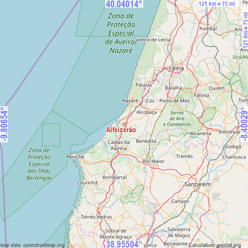
Alfeizerão GPS coordinates[2]
39° 29' 58.956" North, 9° 6' 12.276" West
| Map corner | latitude | longitude |
|---|---|---|
| Upper-left | 40.04014°, | -9.80654° |
| Center: | 39.49971°, | -9.10341° |
| Lower-right: | 38.95504°, | -8.40029° |
| Map W x H: | 120.7×120.7 km | = 75×75mi |
| max Lat: | 42.11337° ⇑52.5% North |
| Alfeizerão: | 39.49971° |
| min Lat: | ⇓47.5% South 32.6448° |
| min Long | Alfeizerão | max Long |
| -31.17847° | -9.10341° | -6.27308° |
| W 21.7%⇐ | ⇒78.3% E |
Elevation
Elevation of Alfeizerão is 22 m = 72 ft, and this is 155 m = 509 ft below average elevation for this country.
| Max E: |
1008 m = 3307 ft | 86.3% |
| Avg. | 177 m = 581 ft | |
| Alfeizerão | 22 m = 72 ft | |
Min E: |
-128 m = -420 ft | 13.7% |
See also: Portugal elevation on elevation.city.
Geographical zone
Alfeizerão is located in North temperate zone (between Tropic of Cancer and the Arctic Circle). Distance of this Northern Tropic circle is 1786 km =1109.8 mi to South.| Distance of | km | miles | from Alfeizerão |
|---|---|---|---|
| North Pole | 5615.1 | 3489.1 | to North |
| Arctic Circle | 3009.2 | 1869.8 | to North |
| Tropic Cancer | 1786 | 1109.8 | to South |
| Equator | 4392 | 2729.1 | to South |


Nearby cities:
15 places around Alfeizerão: (largest is in red/bold)
• Alcobaça
12.3 km =7.6 mi,  61°
61°
• Benedita
14.2 km =8.8 mi,  126°
126°
• Caldas da Rainha
11.1 km =6.9 mi,  195°
195°
• Cela
7.5 km =4.7 mi,  52°
52°
• Famalicão
4.4 km =2.7 mi,  23°
23°
• Foz do Arelho
11.8 km =7.3 mi,  233°
233°
• Nadadouro
11.7 km =7.3 mi,  220°
220°
• Nazaré
11.9 km =7.4 mi,  14°
14°
• Salir de Matos
7.6 km =4.7 mi,  174°
174°
• Salir do Porto
4.6 km =2.9 mi,  263°
263°
• Serra do Bouro
8.1 km =5 mi, 231°
• São Martinho do Porto
2.9 km =1.8 mi,  304°
304°
• Turquel
11.5 km =7.1 mi,  110°
110°
• Valado de Frades
11.7 km =7.3 mi,  36°
36°
• Vestiaria
10.8 km =6.7 mi, 56°
Sources, notices
• [Note1] Compared only with cities in Portugal existing in our database
• [Src1] Map data: © OpenStreetMap contributors (CC-BY-SA)
• [Src2] Other city data from geonames.org with taken over terms of usage.
• [Src3] Geographical zone / Annual Mean Temperature by Robert A. Rohde @ Wikipedia
