Turquel geodata
Turquel (Leiria) is a populated place; located in Portugal in Europe/Lisbon (GMT+1) time zone. With population of 4,434 people, there are 479 cities with bigger population in this country. Compared to other cities in Portugal, 53.8% of cities are located further ↑North; 73.1% of cities are located further →East and 69.8% of cities have lower elevation than Turquel. Note1


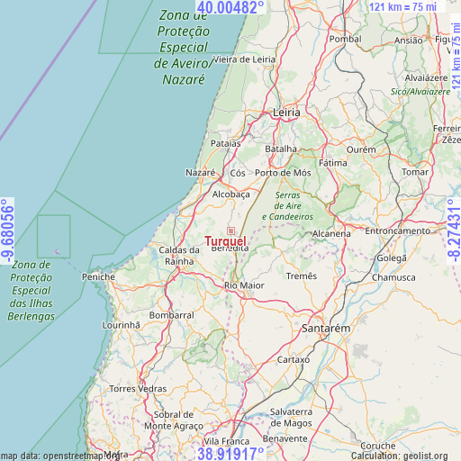
Turquel GPS coordinates[2]
39° 27' 50.796" North, 8° 58' 38.748" West
| Map corner | latitude | longitude |
|---|---|---|
| Upper-left | 40.00482°, | -9.68056° |
| Center: | 39.46411°, | -8.97743° |
| Lower-right: | 38.91917°, | -8.27431° |
| Map W x H: | 120.7×120.7 km | = 75×75mi |
| max Lat: | 42.11337° ⇑53.8% North |
| Turquel: | 39.46411° |
| min Lat: | ⇓46.2% South 32.6448° |
| min Long | Turquel | max Long |
| -31.17847° | -8.97743° | -6.27308° |
| W 26.9%⇐ | ⇒73.1% E |
Elevation
Elevation of Turquel is 201 m = 659 ft, and this is 24 m = 79 ft above average elevation for this country.
| Max E: |
1008 m = 3307 ft | 30.2% |
| Turquel | 201 m 659 ft | |
| Avg. | 177 m = 581 ft | |
Min E: |
-128 m = -420 ft | 69.8% |
See also: Portugal elevation on elevation.city.
Geographical zone
Turquel is located in North temperate zone (between Tropic of Cancer and the Arctic Circle). Distance of this Northern Tropic circle is 1782.1 km =1107.3 mi to South.| Distance of | km | miles | from Turquel |
|---|---|---|---|
| North Pole | 5619.1 | 3491.5 | to North |
| Arctic Circle | 3013.2 | 1872.3 | to North |
| Tropic Cancer | 1782.1 | 1107.3 | to South |
| Equator | 4388 | 2726.6 | to South |


Nearby cities:
15 places around Turquel: (largest is in red/bold)
• Alcanede
14.4 km =8.9 mi,  112°
112°
• Alcobaça
9.8 km =6.1 mi,  359°
359°
• Alfeizerão
11.5 km =7.1 mi,  290°
290°
• Aljubarrota
12.2 km =7.6 mi,  19°
19°
• Alvorninha
10.4 km =6.5 mi,  209°
209°
• Benedita
4.4 km =2.7 mi,  171°
171°
• Caldas da Rainha
15.4 km =9.6 mi,  243°
243°
• Cela
9.8 km =6.1 mi,  330°
330°
• Famalicão
12.1 km =7.5 mi,  311°
311°
• Rio Maior
14.5 km =9 mi, 166°
• Salir de Matos
10.7 km =6.6 mi,  250°
250°
• São Martinho do Porto
14.3 km =8.9 mi, 292°
• Valado de Frades
13.9 km =8.6 mi,  343°
343°
• Vestiaria
10 km =6.2 mi,  349°
349°
• Vidais
12.3 km =7.6 mi, 210°
Sources, notices
• [Note1] Compared only with cities in Portugal existing in our database
• [Src1] Map data: © OpenStreetMap contributors (CC-BY-SA)
• [Src2] Other city data from geonames.org with taken over terms of usage.
• [Src3] Geographical zone / Annual Mean Temperature by Robert A. Rohde @ Wikipedia
