Benfica geodata
Benfica (Lisbon) is a populated place; located in Portugal in Europe/Lisbon (GMT+1) time zone. With population of 36,985 people, there are 32 cities with bigger population in this country. Compared to other cities in Portugal, 71.7% of cities are located further ↑North; 82.9% of cities are located further →East and 55.8% of cities have higher elevation than Benfica. Note1


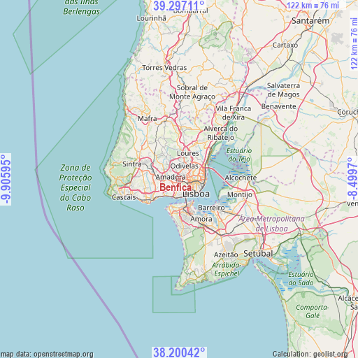
Benfica GPS coordinates[2]
38° 45' 3.132" North, 9° 12' 10.152" West
| Map corner | latitude | longitude |
|---|---|---|
| Upper-left | 39.29711°, | -9.90595° |
| Center: | 38.75087°, | -9.20282° |
| Lower-right: | 38.20042°, | -8.4997° |
| Map W x H: | 121.9×121.9 km | = 75.7×75.7mi |
| max Lat: | 42.11337° ⇑71.7% North |
| Benfica: | 38.75087° |
| min Lat: | ⇓28.3% South 32.6448° |
| min Long | Benfica | max Long |
| -31.17847° | -9.20282° | -6.27308° |
| W 17.1%⇐ | ⇒82.9% E |
Elevation
Elevation of Benfica is 90 m = 295 ft, and this is 87 m = 285 ft below average elevation for this country.
| Max E: |
1008 m = 3307 ft | 55.8% |
| Avg. | 177 m = 581 ft | |
| Benfica | 90 m = 295 ft | |
Min E: |
-128 m = -420 ft | 44.2% |
See also: Portugal elevation on elevation.city.
Geographical zone
Benfica is located in North temperate zone (between Tropic of Cancer and the Arctic Circle). Distance of this Northern Tropic circle is 1702.8 km =1058.1 mi to South.| Distance of | km | miles | from Benfica |
|---|---|---|---|
| North Pole | 5698.4 | 3540.8 | to North |
| Arctic Circle | 3092.5 | 1921.6 | to North |
| Tropic Cancer | 1702.8 | 1058.1 | to South |
| Equator | 4308.7 | 2677.3 | to South |


Nearby cities:
15 places around Benfica: (largest is in red/bold)
• Alfragide
2.5 km =1.6 mi,  214°
214°
• Algés
5.9 km =3.7 mi,  203°
203°
• Alvalade
5.1 km =3.2 mi,  86°
86°
• Amadora
2.5 km =1.6 mi,  277°
277°
• Belas
6 km =3.7 mi,  298°
298°
• Carnaxide
4.6 km =2.9 mi,  235°
235°
• Charneca
6.3 km =3.9 mi,  54°
54°
• Famões
4.2 km =2.6 mi,  351°
351°
• Linda-a-Velha
5.3 km =3.3 mi,  220°
220°
• Odivelas
4.9 km =3 mi,  19°
19°
• Olival do Basto
5.5 km =3.4 mi,  35°
35°
• Pontinha
1.9 km =1.2 mi,  9°
9°
• Póvoa de Santo Adrião
6.3 km =3.9 mi,  29°
29°
• Queluz
4.5 km =2.8 mi, 278°
• Ramada
6 km =3.7 mi, 12°
Sources, notices
• [Note1] Compared only with cities in Portugal existing in our database
• [Src1] Map data: © OpenStreetMap contributors (CC-BY-SA)
• [Src2] Other city data from geonames.org with taken over terms of usage.
• [Src3] Geographical zone / Annual Mean Temperature by Robert A. Rohde @ Wikipedia
