Amarante geodata
Amarante (Porto) is a seat of a second-order administrative division; located in Portugal in Europe/Lisbon (GMT+1) time zone. With population of 6,782 people, there are 326 cities with bigger population in this country. Compared to other cities in Portugal, 82.6% of cities are located further ↓South; 77.1% of cities are located further ←West and 54.1% of cities have higher elevation than Amarante. Note1


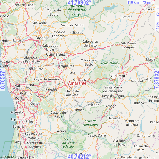
Amarante GPS coordinates[2]
41° 16' 21.756" North, 8° 4' 56.82" West
| Map corner | latitude | longitude |
|---|---|---|
| Upper-left | 41.79902°, | -8.78557° |
| Center: | 41.27271°, | -8.08245° |
| Lower-right: | 40.74212°, | -7.37932° |
| Map W x H: | 117.5×117.5 km | = 73×73mi |
| max Lat: | 42.11337° ⇑17.4% North |
| Amarante: | 41.27271° |
| min Lat: | ⇓82.6% South 32.6448° |
| min Long | Amarante | max Long |
| -31.17847° | -8.08245° | -6.27308° |
| W 77.1%⇐ | ⇒22.9% E |
Elevation
Elevation of Amarante is 96 m = 315 ft, and this is 81 m = 266 ft below average elevation for this country.
| Max E: |
1008 m = 3307 ft | 54.1% |
| Avg. | 177 m = 581 ft | |
| Amarante | 96 m = 315 ft | |
Min E: |
-128 m = -420 ft | 45.9% |
See also: Portugal elevation on elevation.city.
Geographical zone
Amarante is located in North temperate zone (between Tropic of Cancer and the Arctic Circle). Distance of this Northern Tropic circle is 1983.2 km =1232.3 mi to South.| Distance of | km | miles | from Amarante |
|---|---|---|---|
| North Pole | 5418 | 3366.6 | to North |
| Arctic Circle | 2812.1 | 1747.4 | to North |
| Tropic Cancer | 1983.2 | 1232.3 | to South |
| Equator | 4589.1 | 2851.5 | to South |


Nearby cities:
15 places around Amarante: (largest is in red/bold)
• Baião
12.9 km =8 mi,  161°
161°
• Celorico de Basto
14.4 km =8.9 mi,  28°
28°
• Felgueiras
14.1 km =8.8 mi,  318°
318°
• Figueiró
7.7 km =4.8 mi,  292°
292°
• Lousada
16.5 km =10.3 mi,  272°
272°
• Marco de Canavezes
11.3 km =7 mi,  209°
209°
• Margaride
14.2 km =8.8 mi, 316°
• Meinedo
14.9 km =9.3 mi,  259°
259°
• Penafiel
18.2 km =11.3 mi,  246°
246°
• Perafita
17.5 km =10.9 mi,  235°
235°
• Santo Izidoro
8.5 km =5.3 mi,  215°
215°
• Telões
4.8 km =3 mi,  330°
330°
• Valadares
16.3 km =10.1 mi,  148°
148°
• Vila Meã
8.8 km =5.5 mi, 254°
• Vizela
18.5 km =11.5 mi,  311°
311°
Sources, notices
• [Note1] Compared only with cities in Portugal existing in our database
• [Src1] Map data: © OpenStreetMap contributors (CC-BY-SA)
• [Src2] Other city data from geonames.org with taken over terms of usage.
• [Src3] Geographical zone / Annual Mean Temperature by Robert A. Rohde @ Wikipedia
