Felgueiras geodata
Felgueiras (Porto) is a seat of a second-order administrative division; located in Portugal in Europe/Lisbon (GMT+1) time zone. With population of 58,065 people, there are 12 cities with bigger population in this country. Compared to other cities in Portugal, 86% of cities are located further ↓South; 73.4% of cities are located further ←West and 84.4% of cities have lower elevation than Felgueiras. Note1


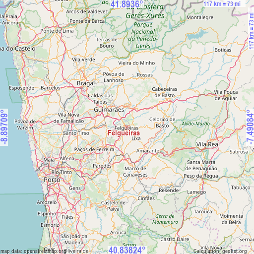
Felgueiras GPS coordinates[2]
41° 22' 5.016" North, 8° 11' 38.256" West
| Map corner | latitude | longitude |
|---|---|---|
| Upper-left | 41.8936°, | -8.89709° |
| Center: | 41.36806°, | -8.19396° |
| Lower-right: | 40.83824°, | -7.49084° |
| Map W x H: | 117.3×117.3 km | = 72.9×72.9mi |
| max Lat: | 42.11337° ⇑14% North |
| Felgueiras: | 41.36806° |
| min Lat: | ⇓86% South 32.6448° |
| min Long | Felgueiras | max Long |
| -31.17847° | -8.19396° | -6.27308° |
| W 73.4%⇐ | ⇒26.6% E |
Elevation
Elevation of Felgueiras is 348 m = 1142 ft, and this is 171 m = 561 ft above average elevation for this country.
| Max E: |
1008 m = 3307 ft | 15.6% |
| Felgueiras | 348 m 1142 ft | |
| Avg. | 177 m = 581 ft | |
Min E: |
-128 m = -420 ft | 84.4% |
See also: Felgueiras elevation on elevation.city.
Geographical zone
Felgueiras is located in North temperate zone (between Tropic of Cancer and the Arctic Circle). Distance of this Northern Tropic circle is 1993.8 km =1238.9 mi to South.| Distance of | km | miles | from Felgueiras |
|---|---|---|---|
| North Pole | 5407.4 | 3360 | to North |
| Arctic Circle | 2801.5 | 1740.8 | to North |
| Tropic Cancer | 1993.8 | 1238.9 | to South |
| Equator | 4599.7 | 2858.1 | to South |


Nearby cities:
15 places around Felgueiras: (largest is in red/bold)
• Arões
9.9 km =6.2 mi,  350°
350°
• Barrosas
8.9 km =5.5 mi,  260°
260°
• Caldas de Vizela
9.7 km =6 mi,  279°
279°
• Fafe
9.4 km =5.8 mi,  10°
10°
• Figueiró
8 km =5 mi,  164°
164°
• Guimarães
12 km =7.5 mi,  314°
314°
• Lousada
12.3 km =7.6 mi,  215°
215°
• Lustosa
10.7 km =6.6 mi,  253°
253°
• Margaride
0.6 km =0.4 mi,  234°
234°
• Serzedo
5.1 km =3.2 mi,  324°
324°
• Telões
9.4 km =5.8 mi,  132°
132°
• Urgeses
10.9 km =6.8 mi, 307°
• Vilarinho
11.5 km =7.1 mi,  265°
265°
• Vizela
4.9 km =3 mi,  289°
289°
• Vizela
6.4 km =4 mi, 293°
Sources, notices
• [Note1] Compared only with cities in Portugal existing in our database
• [Src1] Map data: © OpenStreetMap contributors (CC-BY-SA)
• [Src2] Other city data from geonames.org with taken over terms of usage.
• [Src3] Geographical zone / Annual Mean Temperature by Robert A. Rohde @ Wikipedia
