Tebosa geodata
Tebosa (Braga) is a populated place; located in Portugal in Europe/Lisbon (GMT+1) time zone. With population of 1,129 people, there are 732 cities with bigger population in this country. Compared to other cities in Portugal, 91.2% of cities are located further ↓South; 55.5% of cities are located further ←West and 64% of cities have lower elevation than Tebosa. Note1


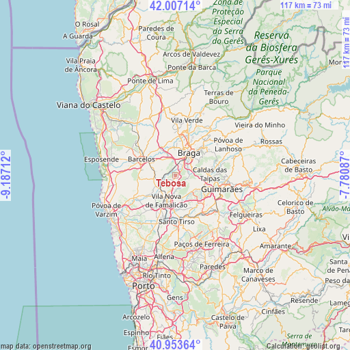
Tebosa GPS coordinates[2]
41° 28' 57.108" North, 8° 29' 2.364" West
| Map corner | latitude | longitude |
|---|---|---|
| Upper-left | 42.00714°, | -9.18712° |
| Center: | 41.48253°, | -8.48399° |
| Lower-right: | 40.95364°, | -7.78087° |
| Map W x H: | 117.1×117.1 km | = 72.8×72.8mi |
| max Lat: | 42.11337° ⇑8.8% North |
| Tebosa: | 41.48253° |
| min Lat: | ⇓91.2% South 32.6448° |
| min Long | Tebosa | max Long |
| -31.17847° | -8.48399° | -6.27308° |
| W 55.5%⇐ | ⇒44.5% E |
Elevation
Elevation of Tebosa is 173 m = 568 ft, and this is 4 m = 13 ft below average elevation for this country.
| Max E: |
1008 m = 3307 ft | 36% |
| Avg. | 177 m = 581 ft | |
| Tebosa | 173 m = 568 ft | |
Min E: |
-128 m = -420 ft | 64% |
See also: Portugal elevation on elevation.city.
Geographical zone
Tebosa is located in North temperate zone (between Tropic of Cancer and the Arctic Circle). Distance of this Northern Tropic circle is 2006.5 km =1246.8 mi to South.| Distance of | km | miles | from Tebosa |
|---|---|---|---|
| North Pole | 5394.6 | 3352 | to North |
| Arctic Circle | 2788.7 | 1732.8 | to North |
| Tropic Cancer | 2006.5 | 1246.8 | to South |
| Equator | 4612.4 | 2866 | to South |


Nearby cities:
15 places around Tebosa: (largest is in red/bold)
• Arcos
6.8 km =4.2 mi,  49°
49°
• Aveleda
4.5 km =2.8 mi,  18°
18°
• Braga
9.2 km =5.7 mi,  35°
35°
• Esporões
6.3 km =3.9 mi,  61°
61°
• Gondizalves
7 km =4.3 mi, 19°
• Guisande
3.2 km =2 mi,  89°
89°
• Joane
7.9 km =4.9 mi,  127°
127°
• Lamas
4.7 km =2.9 mi, 61°
• Oliveira
1.3 km =0.8 mi,  111°
111°
• Real
9.1 km =5.7 mi, 21°
• Ronfe
9.5 km =5.9 mi,  118°
118°
• Semelhe
8.2 km =5.1 mi,  12°
12°
• Vila Nova de Famalicão
8.8 km =5.5 mi,  199°
199°
• Vilaça
3.9 km =2.4 mi,  0°
0°
• Várzea
9.1 km =5.7 mi,  293°
293°
Sources, notices
• [Note1] Compared only with cities in Portugal existing in our database
• [Src1] Map data: © OpenStreetMap contributors (CC-BY-SA)
• [Src2] Other city data from geonames.org with taken over terms of usage.
• [Src3] Geographical zone / Annual Mean Temperature by Robert A. Rohde @ Wikipedia
