Seroa geodata
Seroa (Porto) is a populated place; located in Portugal in Europe/Lisbon (GMT+1) time zone. With population of 4,040 people, there are 513 cities with bigger population in this country. Compared to other cities in Portugal, 81.9% of cities are located further ↓South; 60.5% of cities are located further ←West and 82.8% of cities have lower elevation than Seroa. Note1


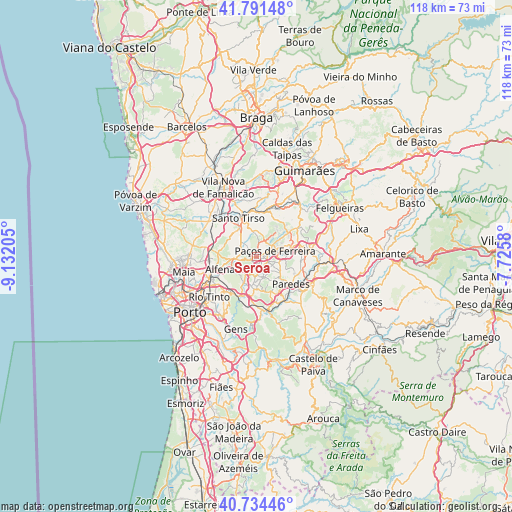
Seroa GPS coordinates[2]
41° 15' 54.396" North, 8° 25' 44.112" West
| Map corner | latitude | longitude |
|---|---|---|
| Upper-left | 41.79148°, | -9.13205° |
| Center: | 41.26511°, | -8.42892° |
| Lower-right: | 40.73446°, | -7.7258° |
| Map W x H: | 117.5×117.5 km | = 73×73mi |
| max Lat: | 42.11337° ⇑18.1% North |
| Seroa: | 41.26511° |
| min Lat: | ⇓81.9% South 32.6448° |
| min Long | Seroa | max Long |
| -31.17847° | -8.42892° | -6.27308° |
| W 60.5%⇐ | ⇒39.5% E |
Elevation
Elevation of Seroa is 324 m = 1063 ft, and this is 147 m = 482 ft above average elevation for this country.
| Max E: |
1008 m = 3307 ft | 17.2% |
| Seroa | 324 m 1063 ft | |
| Avg. | 177 m = 581 ft | |
Min E: |
-128 m = -420 ft | 82.8% |
See also: Portugal elevation on elevation.city.
Geographical zone
Seroa is located in North temperate zone (between Tropic of Cancer and the Arctic Circle). Distance of this Northern Tropic circle is 1982.3 km =1231.7 mi to South.| Distance of | km | miles | from Seroa |
|---|---|---|---|
| North Pole | 5418.8 | 3367.1 | to North |
| Arctic Circle | 2812.9 | 1747.9 | to North |
| Tropic Cancer | 1982.3 | 1231.7 | to South |
| Equator | 4588.3 | 2851 | to South |


Nearby cities:
15 places around Seroa: (largest is in red/bold)
• Alfena
8.6 km =5.3 mi,  248°
248°
• Baltar
8.8 km =5.5 mi,  156°
156°
• Campo
9.4 km =5.8 mi,  198°
198°
• Carvalhosa
6.9 km =4.3 mi,  55°
55°
• Ferreira
7.1 km =4.4 mi,  88°
88°
• Frazão
2.5 km =1.6 mi,  106°
106°
• Freamunde
8.2 km =5.1 mi,  71°
71°
• Gandra
7.1 km =4.4 mi,  183°
183°
• Lamelas
4.6 km =2.9 mi,  303°
303°
• Lordelo
4 km =2.5 mi,  147°
147°
• Paços de Ferreira
4.6 km =2.9 mi, 73°
• Rebordosa
4.9 km =3 mi, 157°
• Sobrado
6.5 km =4 mi, 199°
• São Miguel do Couto
7.9 km =4.9 mi,  339°
339°
• Água Longa
5.6 km =3.5 mi, 252°
Sources, notices
• [Note1] Compared only with cities in Portugal existing in our database
• [Src1] Map data: © OpenStreetMap contributors (CC-BY-SA)
• [Src2] Other city data from geonames.org with taken over terms of usage.
• [Src3] Geographical zone / Annual Mean Temperature by Robert A. Rohde @ Wikipedia
