Sobrado geodata
Sobrado (Porto) is a populated place; located in Portugal in Europe/Lisbon (GMT+1) time zone. With population of 6,703 people, there are 330 cities with bigger population in this country. Compared to other cities in Portugal, 79.5% of cities are located further ↓South; 58.3% of cities are located further ←West and 52.4% of cities have lower elevation than Sobrado. Note1


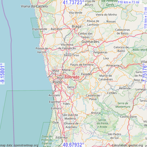
Sobrado GPS coordinates[2]
41° 12' 37.476" North, 8° 27' 17.568" West
| Map corner | latitude | longitude |
|---|---|---|
| Upper-left | 41.73723°, | -9.15801° |
| Center: | 41.21041°, | -8.45488° |
| Lower-right: | 40.67932°, | -7.75176° |
| Map W x H: | 117.6×117.6 km | = 73.1×73.1mi |
| max Lat: | 42.11337° ⇑20.5% North |
| Sobrado: | 41.21041° |
| min Lat: | ⇓79.5% South 32.6448° |
| min Long | Sobrado | max Long |
| -31.17847° | -8.45488° | -6.27308° |
| W 58.3%⇐ | ⇒41.7% E |
Elevation
Elevation of Sobrado is 121 m = 397 ft, and this is 56 m = 184 ft below average elevation for this country.
| Max E: |
1008 m = 3307 ft | 47.6% |
| Avg. | 177 m = 581 ft | |
| Sobrado | 121 m = 397 ft | |
Min E: |
-128 m = -420 ft | 52.4% |
See also: Portugal elevation on elevation.city.
Geographical zone
Sobrado is located in North temperate zone (between Tropic of Cancer and the Arctic Circle). Distance of this Northern Tropic circle is 1976.2 km =1228 mi to South.| Distance of | km | miles | from Sobrado |
|---|---|---|---|
| North Pole | 5424.9 | 3370.9 | to North |
| Arctic Circle | 2819 | 1751.6 | to North |
| Tropic Cancer | 1976.2 | 1228 | to South |
| Equator | 4582.2 | 2847.2 | to South |


Nearby cities:
15 places around Sobrado: (largest is in red/bold)
• Alfena
6.5 km =4 mi,  296°
296°
• Baguim do Monte
7.5 km =4.7 mi,  254°
254°
• Baltar
6 km =3.7 mi,  109°
109°
• Campo
2.9 km =1.8 mi,  196°
196°
• Ermesinde
8.3 km =5.2 mi,  274°
274°
• Frazão
7.1 km =4.4 mi,  40°
40°
• Fânzeres
7.9 km =4.9 mi,  232°
232°
• Gandra
2 km =1.2 mi,  120°
120°
• Lordelo
5.1 km =3.2 mi,  58°
58°
• Rebordosa
4.3 km =2.7 mi,  69°
69°
• Recarei
7.3 km =4.5 mi,  150°
150°
• Seroa
6.5 km =4 mi,  19°
19°
• São Pedro da Cova
8.4 km =5.2 mi,  207°
207°
• Valongo
4.4 km =2.7 mi,  236°
236°
• Água Longa
5.4 km =3.4 mi,  324°
324°
Sources, notices
• [Note1] Compared only with cities in Portugal existing in our database
• [Src1] Map data: © OpenStreetMap contributors (CC-BY-SA)
• [Src2] Other city data from geonames.org with taken over terms of usage.
• [Src3] Geographical zone / Annual Mean Temperature by Robert A. Rohde @ Wikipedia
