Campo geodata
Campo (Porto) is a populated place; located in Portugal in Europe/Lisbon (GMT+1) time zone. With population of 8,916 people, there are 249 cities with bigger population in this country. Compared to other cities in Portugal, 77.6% of cities are located further ↓South; 57.6% of cities are located further ←West and 54.5% of cities have lower elevation than Campo. Note1


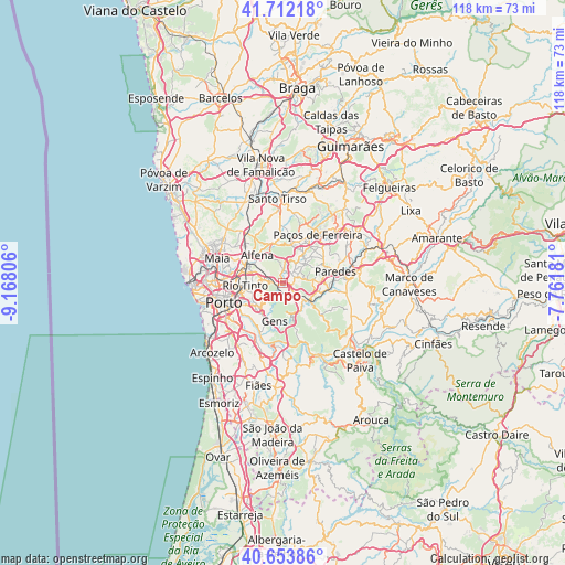
Campo GPS coordinates[2]
41° 11' 6.576" North, 8° 27' 53.748" West
| Map corner | latitude | longitude |
|---|---|---|
| Upper-left | 41.71218°, | -9.16806° |
| Center: | 41.18516°, | -8.46493° |
| Lower-right: | 40.65386°, | -7.76181° |
| Map W x H: | 117.7×117.7 km | = 73.1×73.1mi |
| max Lat: | 42.11337° ⇑22.4% North |
| Campo: | 41.18516° |
| min Lat: | ⇓77.6% South 32.6448° |
| min Long | Campo | max Long |
| -31.17847° | -8.46493° | -6.27308° |
| W 57.6%⇐ | ⇒42.4% E |
Elevation
Elevation of Campo is 127 m = 417 ft, and this is 50 m = 164 ft below average elevation for this country.
| Max E: |
1008 m = 3307 ft | 45.5% |
| Avg. | 177 m = 581 ft | |
| Campo | 127 m = 417 ft | |
Min E: |
-128 m = -420 ft | 54.5% |
See also: Portugal elevation on elevation.city.
Geographical zone
Campo is located in North temperate zone (between Tropic of Cancer and the Arctic Circle). Distance of this Northern Tropic circle is 1973.4 km =1226.2 mi to South.| Distance of | km | miles | from Campo |
|---|---|---|---|
| North Pole | 5427.7 | 3372.6 | to North |
| Arctic Circle | 2821.8 | 1753.4 | to North |
| Tropic Cancer | 1973.4 | 1226.2 | to South |
| Equator | 4579.4 | 2845.5 | to South |


Nearby cities:
15 places around Campo: (largest is in red/bold)
• Alfena
7.6 km =4.7 mi,  318°
318°
• Baguim do Monte
6.4 km =4 mi,  276°
276°
• Baltar
6.5 km =4 mi,  82°
82°
• Ermesinde
8.2 km =5.1 mi,  295°
295°
• Fânzeres
5.8 km =3.6 mi,  250°
250°
• Gandra
3.2 km =2 mi,  55°
55°
• Gondomar
7.2 km =4.5 mi,  231°
231°
• Lordelo
7.5 km =4.7 mi,  43°
43°
• Rebordosa
6.5 km =4 mi,  48°
48°
• Recarei
5.7 km =3.5 mi,  128°
128°
• Rio Tinto
7.9 km =4.9 mi,  264°
264°
• Sobrado
2.9 km =1.8 mi,  16°
16°
• São Pedro da Cova
5.5 km =3.4 mi,  212°
212°
• Valongo
2.8 km =1.7 mi, 278°
• Água Longa
7.5 km =4.7 mi,  341°
341°
Sources, notices
• [Note1] Compared only with cities in Portugal existing in our database
• [Src1] Map data: © OpenStreetMap contributors (CC-BY-SA)
• [Src2] Other city data from geonames.org with taken over terms of usage.
• [Src3] Geographical zone / Annual Mean Temperature by Robert A. Rohde @ Wikipedia
