Alfena geodata
Alfena (Porto) is a populated place; located in Portugal in Europe/Lisbon (GMT+1) time zone. With population of 15,211 people, there are 138 cities with bigger population in this country. Compared to other cities in Portugal, 80.8% of cities are located further ↓South; 53.2% of cities are located further ←West and 51.1% of cities have lower elevation than Alfena. Note1


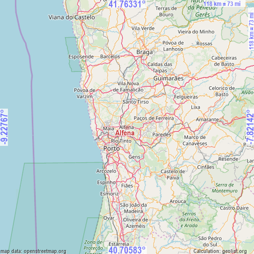
Alfena GPS coordinates[2]
41° 14' 12.156" North, 8° 31' 28.344" West
| Map corner | latitude | longitude |
|---|---|---|
| Upper-left | 41.76331°, | -9.22767° |
| Center: | 41.23671°, | -8.52454° |
| Lower-right: | 40.70583°, | -7.82142° |
| Map W x H: | 117.6×117.6 km | = 73.1×73.1mi |
| max Lat: | 42.11337° ⇑19.2% North |
| Alfena: | 41.23671° |
| min Lat: | ⇓80.8% South 32.6448° |
| min Long | Alfena | max Long |
| -31.17847° | -8.52454° | -6.27308° |
| W 53.2%⇐ | ⇒46.8% E |
Elevation
Elevation of Alfena is 117 m = 384 ft, and this is 60 m = 197 ft below average elevation for this country.
| Max E: |
1008 m = 3307 ft | 48.9% |
| Avg. | 177 m = 581 ft | |
| Alfena | 117 m = 384 ft | |
Min E: |
-128 m = -420 ft | 51.1% |
See also: Portugal elevation on elevation.city.
Geographical zone
Alfena is located in North temperate zone (between Tropic of Cancer and the Arctic Circle). Distance of this Northern Tropic circle is 1979.2 km =1229.8 mi to South.| Distance of | km | miles | from Alfena |
|---|---|---|---|
| North Pole | 5422 | 3369.1 | to North |
| Arctic Circle | 2816.1 | 1749.8 | to North |
| Tropic Cancer | 1979.2 | 1229.8 | to South |
| Equator | 4585.1 | 2849 | to South |


Nearby cities:
15 places around Alfena: (largest is in red/bold)
• Baguim do Monte
5.2 km =3.2 mi,  195°
195°
• Campo
7.6 km =4.7 mi,  138°
138°
• Ermesinde
3.3 km =2.1 mi,  226°
226°
• Fânzeres
7.7 km =4.8 mi,  183°
183°
• Lamelas
7 km =4.3 mi,  36°
36°
• Maia
8 km =5 mi,  269°
269°
• Milheirós
5.9 km =3.7 mi,  245°
245°
• Nogueira
5.2 km =3.2 mi,  276°
276°
• Pedrouços
7.4 km =4.6 mi,  224°
224°
• Rio Tinto
7.1 km =4.4 mi, 204°
• Sobrado
6.5 km =4 mi,  116°
116°
• São Romão do Coronado
6.3 km =3.9 mi,  329°
329°
• Valongo
5.7 km =3.5 mi,  157°
157°
• Água Longa
3 km =1.9 mi,  61°
61°
• Águas Santas
5.2 km =3.2 mi,  235°
235°
Sources, notices
• [Note1] Compared only with cities in Portugal existing in our database
• [Src1] Map data: © OpenStreetMap contributors (CC-BY-SA)
• [Src2] Other city data from geonames.org with taken over terms of usage.
• [Src3] Geographical zone / Annual Mean Temperature by Robert A. Rohde @ Wikipedia
