Senhora da Hora geodata
Senhora da Hora (Porto) is a populated place; located in Portugal in Europe/Lisbon (GMT+1) time zone. With population of 28,930 people, there are 54 cities with bigger population in this country. Compared to other cities in Portugal, 77.7% of cities are located further ↓South; 59% of cities are located further →East and 57.8% of cities have higher elevation than Senhora da Hora. Note1


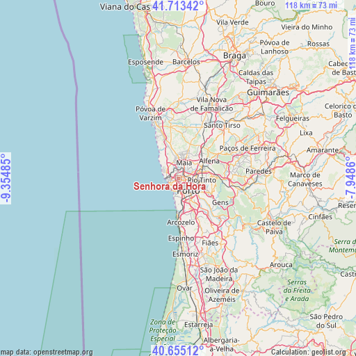
Senhora da Hora GPS coordinates[2]
41° 11' 11.076" North, 8° 39' 6.192" West
| Map corner | latitude | longitude |
|---|---|---|
| Upper-left | 41.71342°, | -9.35485° |
| Center: | 41.18641°, | -8.65172° |
| Lower-right: | 40.65512°, | -7.9486° |
| Map W x H: | 117.7×117.7 km | = 73.1×73.1mi |
| max Lat: | 42.11337° ⇑22.3% North |
| Senhora da Hora: | 41.18641° |
| min Lat: | ⇓77.7% South 32.6448° |
| min Long | Senhora da Hora | max Long |
| -31.17847° | -8.65172° | -6.27308° |
| W 41%⇐ | ⇒59% E |
Elevation
Elevation of Senhora da Hora is 85 m = 279 ft, and this is 92 m = 302 ft below average elevation for this country.
| Max E: |
1008 m = 3307 ft | 57.8% |
| Avg. | 177 m = 581 ft | |
| Senhora da Hora | 85 m = 279 ft | |
Min E: |
-128 m = -420 ft | 42.2% |
See also: Portugal elevation on elevation.city.
Geographical zone
Senhora da Hora is located in North temperate zone (between Tropic of Cancer and the Arctic Circle). Distance of this Northern Tropic circle is 1973.6 km =1226.3 mi to South.| Distance of | km | miles | from Senhora da Hora |
|---|---|---|---|
| North Pole | 5427.6 | 3372.6 | to North |
| Arctic Circle | 2821.7 | 1753.3 | to North |
| Tropic Cancer | 1973.6 | 1226.3 | to South |
| Equator | 4579.5 | 2845.6 | to South |


Nearby cities:
15 places around Senhora da Hora: (largest is in red/bold)
• Canidelo
7 km =4.3 mi,  176°
176°
• Foz do Douro
4.2 km =2.6 mi,  202°
202°
• Guifões
1.9 km =1.2 mi,  310°
310°
• Leça da Palmeira
4.1 km =2.5 mi,  277°
277°
• Leça do Bailio
3.2 km =2 mi,  27°
27°
• Maia
6.1 km =3.8 mi, 25°
• Matosinhos
3.2 km =2 mi,  261°
261°
• Milheirós
6.2 km =3.9 mi,  59°
59°
• Moreira
6.8 km =4.2 mi,  2°
2°
• Pedrouços
5.5 km =3.4 mi,  87°
87°
• Porto
5.3 km =3.3 mi,  140°
140°
• Santa Cruz do Bispo
3.7 km =2.3 mi,  329°
329°
• São Mamede de Infesta
3.5 km =2.2 mi,  79°
79°
• Vila Nova de Gaia
7.7 km =4.8 mi,  154°
154°
• Águas Santas
6.9 km =4.3 mi,  67°
67°
Sources, notices
• [Note1] Compared only with cities in Portugal existing in our database
• [Src1] Map data: © OpenStreetMap contributors (CC-BY-SA)
• [Src2] Other city data from geonames.org with taken over terms of usage.
• [Src3] Geographical zone / Annual Mean Temperature by Robert A. Rohde @ Wikipedia
