Porto geodata
Porto is a seat of a first-order administrative division; located in Portugal in Europe/Lisbon (GMT+1) time zone. With population of 249,633 people, there is 1 city with bigger population in this country. Compared to other cities in Portugal, 76% of cities are located further ↓South; 54% of cities are located further →East and 53.7% of cities have higher elevation than Porto. Note1


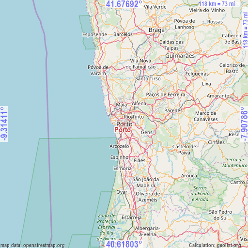
Porto GPS coordinates[2]
41° 8' 58.596" North, 8° 36' 39.564" West
| Map corner | latitude | longitude |
|---|---|---|
| Upper-left | 41.67692°, | -9.31411° |
| Center: | 41.14961°, | -8.61099° |
| Lower-right: | 40.61803°, | -7.90786° |
| Map W x H: | 117.7×117.7 km | = 73.1×73.1mi |
| max Lat: | 42.11337° ⇑24% North |
| Porto: | 41.14961° |
| min Lat: | ⇓76% South 32.6448° |
| min Long | Porto | max Long |
| -31.17847° | -8.61099° | -6.27308° |
| W 46%⇐ | ⇒54% E |
Elevation
Elevation of Porto is 97 m = 318 ft, and this is 80 m = 262 ft below average elevation for this country.
| Max E: |
1008 m = 3307 ft | 53.7% |
| Avg. | 177 m = 581 ft | |
| Porto | 97 m = 318 ft | |
Min E: |
-128 m = -420 ft | 46.3% |
See also: Porto elevation on elevation.city.
Geographical zone
Porto is located in North temperate zone (between Tropic of Cancer and the Arctic Circle). Distance of this Northern Tropic circle is 1969.5 km =1223.8 mi to South.| Distance of | km | miles | from Porto |
|---|---|---|---|
| North Pole | 5431.7 | 3375.1 | to North |
| Arctic Circle | 2825.8 | 1755.9 | to North |
| Tropic Cancer | 1969.5 | 1223.8 | to South |
| Equator | 4575.4 | 2843 | to South |


Nearby cities:
15 places around Porto: (largest is in red/bold)
• Avintes
6.9 km =4.3 mi,  133°
133°
• Canidelo
4.2 km =2.6 mi,  225°
225°
• Foz do Douro
5 km =3.1 mi,  271°
271°
• Fânzeres
7.1 km =4.4 mi,  73°
73°
• Gondomar
6.6 km =4.1 mi,  94°
94°
• Guifões
7.2 km =4.5 mi,  317°
317°
• Oliveira do Douro
3.5 km =2.2 mi,  141°
141°
• Pedrouços
4.8 km =3 mi,  25°
25°
• Rio Tinto
5.4 km =3.4 mi,  53°
53°
• Senhora da Hora
5.3 km =3.3 mi, 320°
• São Mamede de Infesta
4.7 km =2.9 mi,  359°
359°
• Valbom
4.7 km =2.9 mi,  118°
118°
• Vila Nova de Gaia
2.8 km =1.7 mi,  182°
182°
• Vilar de Andorinho
5.3 km =3.3 mi,  156°
156°
• Vilar do Paraíso
6.7 km =4.2 mi,  187°
187°
Sources, notices
• [Note1] Compared only with cities in Portugal existing in our database
• [Src1] Map data: © OpenStreetMap contributors (CC-BY-SA)
• [Src2] Other city data from geonames.org with taken over terms of usage.
• [Src3] Geographical zone / Annual Mean Temperature by Robert A. Rohde @ Wikipedia
