Maia geodata
Maia (Porto) is a seat of a second-order administrative division; located in Portugal in Europe/Lisbon (GMT+1) time zone. With population of 36,426 people, there are 34 cities with bigger population in this country. Compared to other cities in Portugal, 80.7% of cities are located further ↓South; 54.8% of cities are located further →East and 54.8% of cities have higher elevation than Maia. Note1


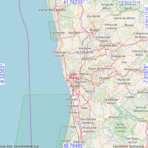
Maia GPS coordinates[2]
41° 14' 8.664" North, 8° 37' 11.64" West
| Map corner | latitude | longitude |
|---|---|---|
| Upper-left | 41.76235°, | -9.32303° |
| Center: | 41.23574°, | -8.6199° |
| Lower-right: | 40.70485°, | -7.91678° |
| Map W x H: | 117.6×117.6 km | = 73.1×73.1mi |
| max Lat: | 42.11337° ⇑19.3% North |
| Maia: | 41.23574° |
| min Lat: | ⇓80.7% South 32.6448° |
| min Long | Maia | max Long |
| -31.17847° | -8.6199° | -6.27308° |
| W 45.2%⇐ | ⇒54.8% E |
Elevation
Elevation of Maia is 93 m = 305 ft, and this is 84 m = 276 ft below average elevation for this country.
| Max E: |
1008 m = 3307 ft | 54.8% |
| Avg. | 177 m = 581 ft | |
| Maia | 93 m = 305 ft | |
Min E: |
-128 m = -420 ft | 45.2% |
See also: Portugal elevation on elevation.city.
Geographical zone
Maia is located in North temperate zone (between Tropic of Cancer and the Arctic Circle). Distance of this Northern Tropic circle is 1979.1 km =1229.8 mi to South.| Distance of | km | miles | from Maia |
|---|---|---|---|
| North Pole | 5422.1 | 3369.1 | to North |
| Arctic Circle | 2816.2 | 1749.9 | to North |
| Tropic Cancer | 1979.1 | 1229.8 | to South |
| Equator | 4585 | 2849 | to South |


Nearby cities:
15 places around Maia: (largest is in red/bold)
• Alfena
8 km =5 mi,  89°
89°
• Anta
3.5 km =2.2 mi,  348°
348°
• Ermesinde
6 km =3.7 mi,  110°
110°
• Gemunde
4.1 km =2.5 mi,  329°
329°
• Guifões
5.9 km =3.7 mi,  223°
223°
• Leça do Bailio
2.9 km =1.8 mi,  204°
204°
• Milheirós
3.5 km =2.2 mi,  131°
131°
• Moreira
2.7 km =1.7 mi,  299°
299°
• Nogueira
2.9 km =1.8 mi,  74°
74°
• Pedrouços
5.9 km =3.7 mi,  151°
151°
• Santa Cruz do Bispo
5.1 km =3.2 mi,  242°
242°
• Senhora da Hora
6.1 km =3.8 mi,  205°
205°
• São Mamede de Infesta
4.9 km =3 mi,  171°
171°
• São Romão do Coronado
7.3 km =4.5 mi,  40°
40°
• Águas Santas
4.6 km =2.9 mi, 127°
Sources, notices
• [Note1] Compared only with cities in Portugal existing in our database
• [Src1] Map data: © OpenStreetMap contributors (CC-BY-SA)
• [Src2] Other city data from geonames.org with taken over terms of usage.
• [Src3] Geographical zone / Annual Mean Temperature by Robert A. Rohde @ Wikipedia
