Milheirós geodata
Milheirós (Porto) is a populated place; located in Portugal in Europe/Lisbon (GMT+1) time zone. With population of 4,342 people, there are 489 cities with bigger population in this country. Compared to other cities in Portugal, 80% of cities are located further ↓South; 52.8% of cities are located further →East and 63.2% of cities have higher elevation than Milheirós. Note1


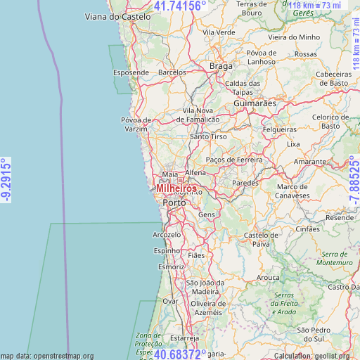
Milheirós GPS coordinates[2]
41° 12' 53.208" North, 8° 35' 18.132" West
| Map corner | latitude | longitude |
|---|---|---|
| Upper-left | 41.74156°, | -9.2915° |
| Center: | 41.21478°, | -8.58837° |
| Lower-right: | 40.68372°, | -7.88525° |
| Map W x H: | 117.6×117.6 km | = 73.1×73.1mi |
| max Lat: | 42.11337° ⇑20% North |
| Milheirós: | 41.21478° |
| min Lat: | ⇓80% South 32.6448° |
| min Long | Milheirós | max Long |
| -31.17847° | -8.58837° | -6.27308° |
| W 47.2%⇐ | ⇒52.8% E |
Elevation
Elevation of Milheirós is 68 m = 223 ft, and this is 109 m = 358 ft below average elevation for this country.
| Max E: |
1008 m = 3307 ft | 63.2% |
| Avg. | 177 m = 581 ft | |
| Milheirós | 68 m = 223 ft | |
Min E: |
-128 m = -420 ft | 36.8% |
See also: Portugal elevation on elevation.city.
Geographical zone
Milheirós is located in North temperate zone (between Tropic of Cancer and the Arctic Circle). Distance of this Northern Tropic circle is 1976.7 km =1228.3 mi to South.| Distance of | km | miles | from Milheirós |
|---|---|---|---|
| North Pole | 5424.4 | 3370.6 | to North |
| Arctic Circle | 2818.5 | 1751.3 | to North |
| Tropic Cancer | 1976.7 | 1228.3 | to South |
| Equator | 4582.7 | 2847.6 | to South |


Nearby cities:
15 places around Milheirós: (largest is in red/bold)
• Alfena
5.9 km =3.7 mi,  65°
65°
• Anta
6.6 km =4.1 mi,  329°
329°
• Baguim do Monte
4.7 km =2.9 mi,  122°
122°
• Ermesinde
2.9 km =1.8 mi,  86°
86°
• Fânzeres
7.2 km =4.5 mi,  136°
136°
• Guifões
7 km =4.3 mi,  254°
254°
• Leça do Bailio
3.8 km =2.4 mi,  265°
265°
• Maia
3.5 km =2.2 mi,  311°
311°
• Moreira
6.2 km =3.9 mi, 306°
• Nogueira
3.1 km =1.9 mi,  2°
2°
• Pedrouços
2.9 km =1.8 mi,  176°
176°
• Rio Tinto
4.7 km =2.9 mi,  148°
148°
• Senhora da Hora
6.2 km =3.9 mi,  239°
239°
• São Mamede de Infesta
3.2 km =2 mi,  216°
216°
• Águas Santas
1.2 km =0.7 mi, 116°
Sources, notices
• [Note1] Compared only with cities in Portugal existing in our database
• [Src1] Map data: © OpenStreetMap contributors (CC-BY-SA)
• [Src2] Other city data from geonames.org with taken over terms of usage.
• [Src3] Geographical zone / Annual Mean Temperature by Robert A. Rohde @ Wikipedia
