Guifões geodata
Guifões (Porto) is a populated place; located in Portugal in Europe/Lisbon (GMT+1) time zone. With population of 9,231 people, there are 238 cities with bigger population in this country. Compared to other cities in Portugal, 78.7% of cities are located further ↓South; 60.4% of cities are located further →East and 59.3% of cities have higher elevation than Guifões. Note1


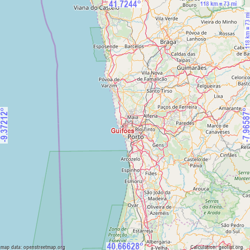
Guifões GPS coordinates[2]
41° 11' 50.928" North, 8° 40' 8.364" West
| Map corner | latitude | longitude |
|---|---|---|
| Upper-left | 41.7244°, | -9.37212° |
| Center: | 41.19748°, | -8.66899° |
| Lower-right: | 40.66628°, | -7.96587° |
| Map W x H: | 117.7×117.7 km | = 73.1×73.1mi |
| max Lat: | 42.11337° ⇑21.3% North |
| Guifões: | 41.19748° |
| min Lat: | ⇓78.7% South 32.6448° |
| min Long | Guifões | max Long |
| -31.17847° | -8.66899° | -6.27308° |
| W 39.6%⇐ | ⇒60.4% E |
Elevation
Elevation of Guifões is 80 m = 262 ft, and this is 97 m = 318 ft below average elevation for this country.
| Max E: |
1008 m = 3307 ft | 59.3% |
| Avg. | 177 m = 581 ft | |
| Guifões | 80 m = 262 ft | |
Min E: |
-128 m = -420 ft | 40.7% |
See also: Portugal elevation on elevation.city.
Geographical zone
Guifões is located in North temperate zone (between Tropic of Cancer and the Arctic Circle). Distance of this Northern Tropic circle is 1974.8 km =1227.1 mi to South.| Distance of | km | miles | from Guifões |
|---|---|---|---|
| North Pole | 5426.3 | 3371.7 | to North |
| Arctic Circle | 2820.4 | 1752.5 | to North |
| Tropic Cancer | 1974.8 | 1227.1 | to South |
| Equator | 4580.7 | 2846.3 | to South |


Nearby cities:
15 places around Guifões: (largest is in red/bold)
• Foz do Douro
5.2 km =3.2 mi,  182°
182°
• Gemunde
8.1 km =5 mi,  14°
14°
• Lavra
8 km =5 mi,  328°
328°
• Leça da Palmeira
2.7 km =1.7 mi,  254°
254°
• Leça do Bailio
3.3 km =2.1 mi,  60°
60°
• Maia
5.9 km =3.7 mi,  43°
43°
• Matosinhos
2.4 km =1.5 mi,  224°
224°
• Milheirós
7 km =4.3 mi,  74°
74°
• Moreira
5.8 km =3.6 mi,  17°
17°
• Pedrouços
7 km =4.3 mi,  97°
97°
• Porto
7.2 km =4.5 mi,  137°
137°
• Santa Cruz do Bispo
2 km =1.2 mi,  347°
347°
• Senhora da Hora
1.9 km =1.2 mi,  130°
130°
• São Mamede de Infesta
4.9 km =3 mi, 97°
• Águas Santas
7.9 km =4.9 mi,  79°
79°
Sources, notices
• [Note1] Compared only with cities in Portugal existing in our database
• [Src1] Map data: © OpenStreetMap contributors (CC-BY-SA)
• [Src2] Other city data from geonames.org with taken over terms of usage.
• [Src3] Geographical zone / Annual Mean Temperature by Robert A. Rohde @ Wikipedia
