Pedrouços geodata
Pedrouços (Porto) is a populated place; located in Portugal in Europe/Lisbon (GMT+1) time zone. With population of 12,553 people, there are 162 cities with bigger population in this country. Compared to other cities in Portugal, 77.8% of cities are located further ↓South; 52.6% of cities are located further →East and 60.3% of cities have lower elevation than Pedrouços. Note1


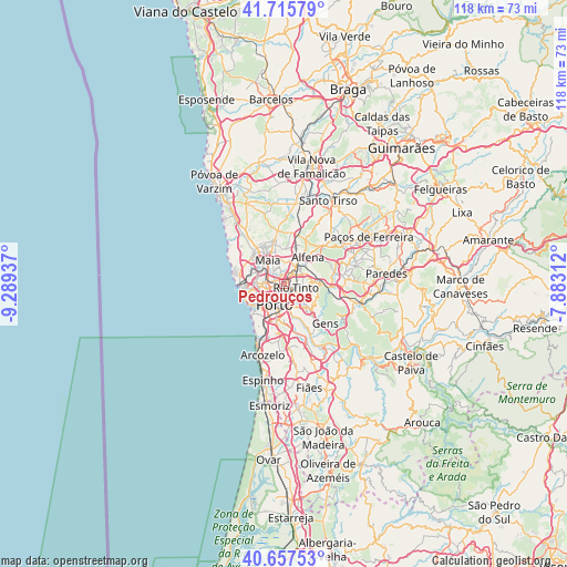
Pedrouços GPS coordinates[2]
41° 11' 19.68" North, 8° 35' 10.464" West
| Map corner | latitude | longitude |
|---|---|---|
| Upper-left | 41.71579°, | -9.28937° |
| Center: | 41.1888°, | -8.58624° |
| Lower-right: | 40.65753°, | -7.88312° |
| Map W x H: | 117.7×117.7 km | = 73.1×73.1mi |
| max Lat: | 42.11337° ⇑22.2% North |
| Pedrouços: | 41.1888° |
| min Lat: | ⇓77.8% South 32.6448° |
| min Long | Pedrouços | max Long |
| -31.17847° | -8.58624° | -6.27308° |
| W 47.4%⇐ | ⇒52.6% E |
Elevation
Elevation of Pedrouços is 156 m = 512 ft, and this is 21 m = 69 ft below average elevation for this country.
| Max E: |
1008 m = 3307 ft | 39.7% |
| Avg. | 177 m = 581 ft | |
| Pedrouços | 156 m = 512 ft | |
Min E: |
-128 m = -420 ft | 60.3% |
See also: Portugal elevation on elevation.city.
Geographical zone
Pedrouços is located in North temperate zone (between Tropic of Cancer and the Arctic Circle). Distance of this Northern Tropic circle is 1973.8 km =1226.5 mi to South.| Distance of | km | miles | from Pedrouços |
|---|---|---|---|
| North Pole | 5427.3 | 3372.4 | to North |
| Arctic Circle | 2821.4 | 1753.1 | to North |
| Tropic Cancer | 1973.8 | 1226.5 | to South |
| Equator | 4579.8 | 2845.8 | to South |


Nearby cities:
15 places around Pedrouços: (largest is in red/bold)
• Baguim do Monte
3.8 km =2.4 mi,  84°
84°
• Ermesinde
4.1 km =2.5 mi,  41°
41°
• Fânzeres
5.3 km =3.3 mi,  116°
116°
• Gondomar
6.7 km =4.2 mi,  137°
137°
• Guifões
7 km =4.3 mi,  277°
277°
• Leça do Bailio
4.8 km =3 mi,  302°
302°
• Maia
5.9 km =3.7 mi,  331°
331°
• Milheirós
2.9 km =1.8 mi,  356°
356°
• Nogueira
6 km =3.7 mi, 359°
• Porto
4.8 km =3 mi,  205°
205°
• Rio Tinto
2.5 km =1.6 mi, 116°
• Senhora da Hora
5.5 km =3.4 mi,  267°
267°
• São Mamede de Infesta
2.1 km =1.3 mi, 279°
• Valbom
6.9 km =4.3 mi,  162°
162°
• Águas Santas
2.5 km =1.6 mi,  19°
19°
Sources, notices
• [Note1] Compared only with cities in Portugal existing in our database
• [Src1] Map data: © OpenStreetMap contributors (CC-BY-SA)
• [Src2] Other city data from geonames.org with taken over terms of usage.
• [Src3] Geographical zone / Annual Mean Temperature by Robert A. Rohde @ Wikipedia
