Vinhais geodata
Vinhais (Bragança) is a seat of a second-order administrative division; located in Portugal in Europe/Lisbon (GMT+1) time zone. With population of 9,066 people, there are 243 cities with bigger population in this country. Compared to other cities in Portugal, 98.9% of cities are located further ↓South; 98.6% of cities are located further ←West and 97.6% of cities have lower elevation than Vinhais. Note1


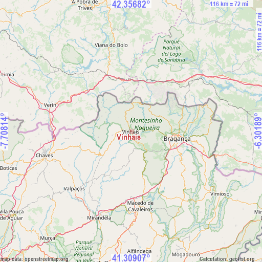
Vinhais GPS coordinates[2]
41° 50' 6.324" North, 7° 0' 18.036" West
| Map corner | latitude | longitude |
|---|---|---|
| Upper-left | 42.35682°, | -7.70814° |
| Center: | 41.83509°, | -7.00501° |
| Lower-right: | 41.30907°, | -6.30189° |
| Map W x H: | 116.5×116.5 km | = 72.4×72.4mi |
| max Lat: | 42.11337° ⇑1.1% North |
| Vinhais: | 41.83509° |
| min Lat: | ⇓98.9% South 32.6448° |
| min Long | Vinhais | max Long |
| -31.17847° | -7.00501° | -6.27308° |
| W 98.6%⇐ | ⇒1.4% E |
Elevation
Elevation of Vinhais is 706 m = 2316 ft, and this is 529 m = 1736 ft above average elevation for this country.
| Max E: |
1008 m = 3307 ft | 2.4% |
| Vinhais | 706 m 2316 ft | |
| Avg. | 177 m = 581 ft | |
Min E: |
-128 m = -420 ft | 97.6% |
See also: Portugal elevation on elevation.city.
Geographical zone
Vinhais is located in North temperate zone (between Tropic of Cancer and the Arctic Circle). Distance of this Northern Tropic circle is 2045.7 km =1271.1 mi to South.| Distance of | km | miles | from Vinhais |
|---|---|---|---|
| North Pole | 5355.4 | 3327.7 | to North |
| Arctic Circle | 2749.5 | 1708.5 | to North |
| Tropic Cancer | 2045.7 | 1271.1 | to South |
| Equator | 4651.6 | 2890.4 | to South |


Nearby cities:
15 places around Vinhais: (largest is in red/bold)
• Alfândega da Fé
54.8 km =34.1 mi,  176°
176°
• Boticas
57.4 km =35.7 mi,  253°
253°
• Bragança
20.8 km =12.9 mi,  99°
99°
• Chaves
39.9 km =24.8 mi, 254°
• Macedo de Cavaleiros
33.2 km =20.6 mi,  173°
173°
• Mirandela
41.5 km =25.8 mi,  201°
201°
• Mogadouro
60.2 km =37.4 mi,  156°
156°
• Montalegre
65 km =40.4 mi,  268°
268°
• Murça
60.6 km =37.7 mi,  218°
218°
• Samil
21.6 km =13.4 mi,  107°
107°
• Santa Cruz
39.3 km =24.4 mi,  257°
257°
• Valpaços
35.8 km =22.2 mi,  225°
225°
• Vila Flor
59.8 km =37.2 mi,  191°
191°
• Vila Pouca de Aguiar
64.8 km =40.3 mi, 234°
• Vimioso
48.4 km =30.1 mi,  125°
125°
Sources, notices
• [Note1] Compared only with cities in Portugal existing in our database
• [Src1] Map data: © OpenStreetMap contributors (CC-BY-SA)
• [Src2] Other city data from geonames.org with taken over terms of usage.
• [Src3] Geographical zone / Annual Mean Temperature by Robert A. Rohde @ Wikipedia
