Bragança geodata
Bragança is a seat of a first-order administrative division; located in Portugal in Europe/Lisbon (GMT+1) time zone. With population of 34,375 people, there are 39 cities with bigger population in this country. Compared to other cities in Portugal, 98.5% of cities are located further ↓South; 99.3% of cities are located further ←West and 96.5% of cities have lower elevation than Bragança. Note1


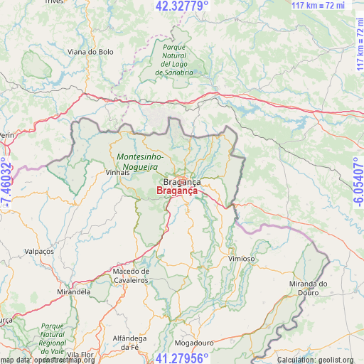
Bragança GPS coordinates[2]
41° 48' 20.952" North, 6° 45' 25.884" West
| Map corner | latitude | longitude |
|---|---|---|
| Upper-left | 42.32779°, | -7.46032° |
| Center: | 41.80582°, | -6.75719° |
| Lower-right: | 41.27956°, | -6.05407° |
| Map W x H: | 116.6×116.6 km | = 72.5×72.5mi |
| max Lat: | 42.11337° ⇑1.5% North |
| Bragança: | 41.80582° |
| min Lat: | ⇓98.5% South 32.6448° |
| min Long | Bragança | max Long |
| -31.17847° | -6.75719° | -6.27308° |
| W 99.3%⇐ | ⇒0.7% E |
Elevation
Elevation of Bragança is 673 m = 2208 ft, and this is 496 m = 1627 ft above average elevation for this country.
| Max E: |
1008 m = 3307 ft | 3.5% |
| Bragança | 673 m 2208 ft | |
| Avg. | 177 m = 581 ft | |
Min E: |
-128 m = -420 ft | 96.5% |
See also: Portugal elevation on elevation.city.
Geographical zone
Bragança is located in North temperate zone (between Tropic of Cancer and the Arctic Circle). Distance of this Northern Tropic circle is 2042.5 km =1269.2 mi to South.| Distance of | km | miles | from Bragança |
|---|---|---|---|
| North Pole | 5358.7 | 3329.7 | to North |
| Arctic Circle | 2752.8 | 1710.5 | to North |
| Tropic Cancer | 2042.5 | 1269.2 | to South |
| Equator | 4648.4 | 2888.4 | to South |


Nearby cities:
15 places around Bragança: (largest is in red/bold)
• Alfândega da Fé
54.2 km =33.7 mi,  198°
198°
• Chaves
59.5 km =37 mi,  262°
262°
• Lagoaça
68.3 km =42.4 mi,  177°
177°
• Macedo de Cavaleiros
34.2 km =21.3 mi,  209°
209°
• Miranda do Douro
52.9 km =32.9 mi,  130°
130°
• Mirandela
50.3 km =31.3 mi,  225°
225°
• Mogadouro
51.9 km =32.2 mi, 175°
• Murça
73.1 km =45.4 mi, 232°
• Samil
3.3 km =2.1 mi, 179°
• Santa Cruz
59.2 km =36.8 mi,  265°
265°
• Sendim
54.1 km =33.6 mi,  149°
149°
• Valpaços
51 km =31.7 mi,  244°
244°
• Vila Flor
64.3 km =40 mi, 210°
• Vimioso
31.1 km =19.3 mi,  142°
142°
• Vinhais
20.8 km =12.9 mi,  279°
279°
Sources, notices
• [Note1] Compared only with cities in Portugal existing in our database
• [Src1] Map data: © OpenStreetMap contributors (CC-BY-SA)
• [Src2] Other city data from geonames.org with taken over terms of usage.
• [Src3] Geographical zone / Annual Mean Temperature by Robert A. Rohde @ Wikipedia
