São Roque geodata
São Roque (Aveiro) is a populated place; located in Portugal in Europe/Lisbon (GMT+1) time zone. With population of 5,575 people, there are 389 cities with bigger population in this country. Compared to other cities in Portugal, 67.4% of cities are located further ↓South; 56.4% of cities are located further ←West and 71.2% of cities have lower elevation than São Roque. Note1


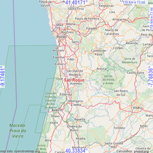
São Roque GPS coordinates[2]
40° 52' 19.776" North, 8° 28' 17.364" West
| Map corner | latitude | longitude |
|---|---|---|
| Upper-left | 41.40171°, | -9.17461° |
| Center: | 40.87216°, | -8.47149° |
| Lower-right: | 40.33834°, | -7.76836° |
| Map W x H: | 118.2×118.2 km | = 73.4×73.4mi |
| max Lat: | 42.11337° ⇑32.6% North |
| São Roque: | 40.87216° |
| min Lat: | ⇓67.4% South 32.6448° |
| min Long | São Roque | max Long |
| -31.17847° | -8.47149° | -6.27308° |
| W 56.4%⇐ | ⇒43.6% E |
Elevation
Elevation of São Roque is 208 m = 682 ft, and this is 31 m = 102 ft above average elevation for this country.
| Max E: |
1008 m = 3307 ft | 28.8% |
| São Roque | 208 m 682 ft | |
| Avg. | 177 m = 581 ft | |
Min E: |
-128 m = -420 ft | 71.2% |
See also: Portugal elevation on elevation.city.
Geographical zone
São Roque is located in North temperate zone (between Tropic of Cancer and the Arctic Circle). Distance of this Northern Tropic circle is 1938.6 km =1204.6 mi to South.| Distance of | km | miles | from São Roque |
|---|---|---|---|
| North Pole | 5462.5 | 3394.2 | to North |
| Arctic Circle | 2856.6 | 1775 | to North |
| Tropic Cancer | 1938.6 | 1204.6 | to South |
| Equator | 4544.6 | 2823.9 | to South |


Nearby cities:
15 places around São Roque: (largest is in red/bold)
• Arrifana
5.3 km =3.3 mi,  336°
336°
• Avanca
11.1 km =6.9 mi,  229°
229°
• Cucujães
3 km =1.9 mi,  274°
274°
• Espargo
10.5 km =6.5 mi,  303°
303°
• Feira
8.4 km =5.2 mi,  314°
314°
• Macieira de Cambra
8.4 km =5.2 mi,  99°
99°
• Milheirós de Poiares
5.5 km =3.4 mi,  3°
3°
• Mosteirô
5.9 km =3.7 mi, 299°
• Oliveira de Azemeis
3.5 km =2.2 mi,  185°
185°
• Sanfins
7.9 km =4.9 mi,  324°
324°
• São João
11.4 km =7.1 mi, 267°
• São João da Madeira
3.5 km =2.2 mi,  333°
333°
• Vale de Cambra
7 km =4.3 mi,  110°
110°
• Vila Chã
0.7 km =0.4 mi,  146°
146°
• Válega
10 km =6.2 mi,  246°
246°
Sources, notices
• [Note1] Compared only with cities in Portugal existing in our database
• [Src1] Map data: © OpenStreetMap contributors (CC-BY-SA)
• [Src2] Other city data from geonames.org with taken over terms of usage.
• [Src3] Geographical zone / Annual Mean Temperature by Robert A. Rohde @ Wikipedia
