Sanfins geodata
Sanfins (Aveiro) is a populated place; located in Portugal in Europe/Lisbon (GMT+1) time zone. With population of 1,970 people, there are 651 cities with bigger population in this country. Compared to other cities in Portugal, 68.7% of cities are located further ↓South; 52.8% of cities are located further ←West and 62.4% of cities have lower elevation than Sanfins. Note1


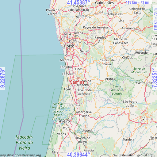
Sanfins GPS coordinates[2]
40° 55' 47.244" North, 8° 31' 32.268" West
| Map corner | latitude | longitude |
|---|---|---|
| Upper-left | 41.45887°, | -9.22876° |
| Center: | 40.92979°, | -8.52563° |
| Lower-right: | 40.39644°, | -7.82251° |
| Map W x H: | 118.1×118.1 km | = 73.4×73.4mi |
| max Lat: | 42.11337° ⇑31.3% North |
| Sanfins: | 40.92979° |
| min Lat: | ⇓68.7% South 32.6448° |
| min Long | Sanfins | max Long |
| -31.17847° | -8.52563° | -6.27308° |
| W 52.8%⇐ | ⇒47.2% E |
Elevation
Elevation of Sanfins is 167 m = 548 ft, and this is 10 m = 33 ft below average elevation for this country.
| Max E: |
1008 m = 3307 ft | 37.6% |
| Avg. | 177 m = 581 ft | |
| Sanfins | 167 m = 548 ft | |
Min E: |
-128 m = -420 ft | 62.4% |
See also: Portugal elevation on elevation.city.
Geographical zone
Sanfins is located in North temperate zone (between Tropic of Cancer and the Arctic Circle). Distance of this Northern Tropic circle is 1945 km =1208.6 mi to South.| Distance of | km | miles | from Sanfins |
|---|---|---|---|
| North Pole | 5456.1 | 3390.3 | to North |
| Arctic Circle | 2850.2 | 1771 | to North |
| Tropic Cancer | 1945 | 1208.6 | to South |
| Equator | 4551 | 2827.9 | to South |


Nearby cities:
15 places around Sanfins: (largest is in red/bold)
• Arrifana
2.9 km =1.8 mi,  122°
122°
• Cucujães
6.4 km =4 mi,  165°
165°
• Espargo
4.2 km =2.6 mi,  262°
262°
• Feira
1.5 km =0.9 mi,  251°
251°
• Fiães
7.2 km =4.5 mi,  0°
0°
• Lamas
7.2 km =4.5 mi,  329°
329°
• Lobão
7.2 km =4.5 mi,  27°
27°
• Lourosa
6.4 km =4 mi,  340°
340°
• Milheirós de Poiares
4.9 km =3 mi,  100°
100°
• Mosteirô
3.5 km =2.2 mi,  188°
188°
• Paços de Brandão
7 km =4.3 mi,  316°
316°
• Rio Meão
5.4 km =3.4 mi,  305°
305°
• São João da Madeira
4.4 km =2.7 mi,  137°
137°
• São João de Ver
3.6 km =2.2 mi, 322°
• São Roque
7.9 km =4.9 mi, 144°
Sources, notices
• [Note1] Compared only with cities in Portugal existing in our database
• [Src1] Map data: © OpenStreetMap contributors (CC-BY-SA)
• [Src2] Other city data from geonames.org with taken over terms of usage.
• [Src3] Geographical zone / Annual Mean Temperature by Robert A. Rohde @ Wikipedia
