Feira geodata
Feira (Aveiro) is a seat of a second-order administrative division; located in Portugal in Europe/Lisbon (GMT+1) time zone. With population of 16,376 people, there are 130 cities with bigger population in this country. Compared to other cities in Portugal, 68.6% of cities are located further ↓South; 51.7% of cities are located further ←West and 52.6% of cities have lower elevation than Feira. Note1


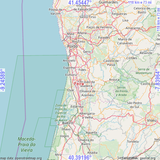
Feira GPS coordinates[2]
40° 55' 31.26" North, 8° 32' 33.972" West
| Map corner | latitude | longitude |
|---|---|---|
| Upper-left | 41.45447°, | -9.24589° |
| Center: | 40.92535°, | -8.54277° |
| Lower-right: | 40.39196°, | -7.83964° |
| Map W x H: | 118.1×118.1 km | = 73.4×73.4mi |
| max Lat: | 42.11337° ⇑31.4% North |
| Feira: | 40.92535° |
| min Lat: | ⇓68.6% South 32.6448° |
| min Long | Feira | max Long |
| -31.17847° | -8.54277° | -6.27308° |
| W 51.7%⇐ | ⇒48.3% E |
Elevation
Elevation of Feira is 122 m = 400 ft, and this is 55 m = 180 ft below average elevation for this country.
| Max E: |
1008 m = 3307 ft | 47.4% |
| Avg. | 177 m = 581 ft | |
| Feira | 122 m = 400 ft | |
Min E: |
-128 m = -420 ft | 52.6% |
See also: Portugal elevation on elevation.city.
Geographical zone
Feira is located in North temperate zone (between Tropic of Cancer and the Arctic Circle). Distance of this Northern Tropic circle is 1944.6 km =1208.3 mi to South.| Distance of | km | miles | from Feira |
|---|---|---|---|
| North Pole | 5456.6 | 3390.6 | to North |
| Arctic Circle | 2850.7 | 1771.3 | to North |
| Tropic Cancer | 1944.6 | 1208.3 | to South |
| Equator | 4550.5 | 2827.5 | to South |


Nearby cities:
15 places around Feira: (largest is in red/bold)
• Arrifana
4 km =2.5 mi,  105°
105°
• Cortegaça
7.1 km =4.4 mi,  291°
291°
• Cucujães
6.4 km =4 mi,  152°
152°
• Esmoriz
8 km =5 mi,  296°
296°
• Espargo
2.7 km =1.7 mi,  268°
268°
• Fiães
7.8 km =4.8 mi,  10°
10°
• Lamas
7.1 km =4.4 mi,  341°
341°
• Lourosa
6.6 km =4.1 mi,  353°
353°
• Milheirós de Poiares
6.3 km =3.9 mi,  93°
93°
• Mosteirô
3.1 km =1.9 mi,  163°
163°
• Paços de Brandão
6.5 km =4 mi,  328°
328°
• Rio Meão
4.7 km =2.9 mi,  320°
320°
• Sanfins
1.5 km =0.9 mi,  71°
71°
• São João da Madeira
5.2 km =3.2 mi,  121°
121°
• São João de Ver
3.4 km =2.1 mi, 348°
Sources, notices
• [Note1] Compared only with cities in Portugal existing in our database
• [Src1] Map data: © OpenStreetMap contributors (CC-BY-SA)
• [Src2] Other city data from geonames.org with taken over terms of usage.
• [Src3] Geographical zone / Annual Mean Temperature by Robert A. Rohde @ Wikipedia
