Cucujães geodata
Cucujães (Aveiro) is a populated place; located in Portugal in Europe/Lisbon (GMT+1) time zone. With population of 11,087 people, there are 194 cities with bigger population in this country. Compared to other cities in Portugal, 67.5% of cities are located further ↓South; 54.2% of cities are located further ←West and 75% of cities have lower elevation than Cucujães. Note1


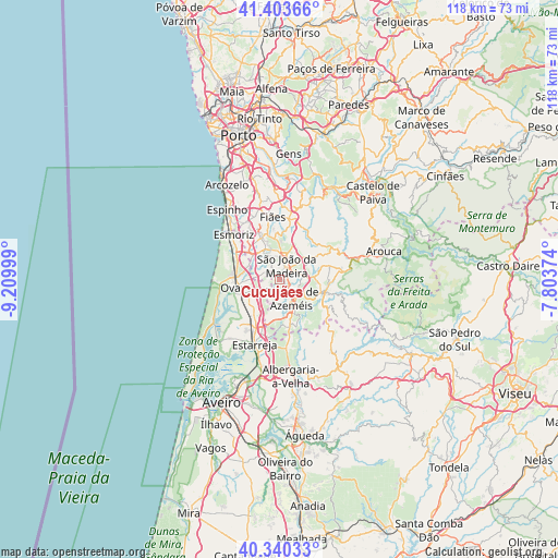
Cucujães GPS coordinates[2]
40° 52' 26.868" North, 8° 30' 24.732" West
| Map corner | latitude | longitude |
|---|---|---|
| Upper-left | 41.40366°, | -9.20999° |
| Center: | 40.87413°, | -8.50687° |
| Lower-right: | 40.34033°, | -7.80374° |
| Map W x H: | 118.2×118.2 km | = 73.4×73.4mi |
| max Lat: | 42.11337° ⇑32.5% North |
| Cucujães: | 40.87413° |
| min Lat: | ⇓67.5% South 32.6448° |
| min Long | Cucujães | max Long |
| -31.17847° | -8.50687° | -6.27308° |
| W 54.2%⇐ | ⇒45.8% E |
Elevation
Elevation of Cucujães is 236 m = 774 ft, and this is 59 m = 194 ft above average elevation for this country.
| Max E: |
1008 m = 3307 ft | 25% |
| Cucujães | 236 m 774 ft | |
| Avg. | 177 m = 581 ft | |
Min E: |
-128 m = -420 ft | 75% |
See also: Portugal elevation on elevation.city.
Geographical zone
Cucujães is located in North temperate zone (between Tropic of Cancer and the Arctic Circle). Distance of this Northern Tropic circle is 1938.9 km =1204.8 mi to South.| Distance of | km | miles | from Cucujães |
|---|---|---|---|
| North Pole | 5462.3 | 3394.1 | to North |
| Arctic Circle | 2856.4 | 1774.9 | to North |
| Tropic Cancer | 1938.9 | 1204.8 | to South |
| Equator | 4544.8 | 2824 | to South |


Nearby cities:
15 places around Cucujães: (largest is in red/bold)
• Arrifana
4.7 km =2.9 mi,  10°
10°
• Avanca
9.2 km =5.7 mi,  216°
216°
• Espargo
8 km =5 mi,  314°
314°
• Feira
6.4 km =4 mi,  332°
332°
• Milheirós de Poiares
6.2 km =3.9 mi,  31°
31°
• Mosteirô
3.4 km =2.1 mi,  322°
322°
• Oliveira de Azemeis
4.5 km =2.8 mi,  144°
144°
• Sanfins
6.4 km =4 mi,  345°
345°
• São João
8.4 km =5.2 mi,  265°
265°
• São João da Madeira
3.3 km =2.1 mi, 25°
• São João de Ver
9.8 km =6.1 mi,  337°
337°
• São Roque
3 km =1.9 mi,  94°
94°
• Vale de Cambra
9.9 km =6.2 mi,  105°
105°
• Vila Chã
3.5 km =2.2 mi,  103°
103°
• Válega
7.5 km =4.7 mi,  235°
235°
Sources, notices
• [Note1] Compared only with cities in Portugal existing in our database
• [Src1] Map data: © OpenStreetMap contributors (CC-BY-SA)
• [Src2] Other city data from geonames.org with taken over terms of usage.
• [Src3] Geographical zone / Annual Mean Temperature by Robert A. Rohde @ Wikipedia
