Lamas geodata
Lamas (Aveiro) is a populated place; located in Portugal in Europe/Lisbon (GMT+1) time zone. With population of 5,628 people, there are 385 cities with bigger population in this country. Compared to other cities in Portugal, 70% of cities are located further ↓South; 50.6% of cities are located further →East and 57.1% of cities have lower elevation than Lamas. Note1
Administrative division(s):
- Level 1: Aveiro
- Level 2: Santa Maria da Feira
- Level 3: Santa Maria de Lamas


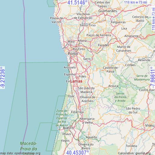
Lamas GPS coordinates[2]
40° 59' 9.492" North, 8° 34' 9.228" West
| Map corner | latitude | longitude |
|---|---|---|
| Upper-left | 41.5146°, | -9.27236° |
| Center: | 40.98597°, | -8.56923° |
| Lower-right: | 40.45307°, | -7.86611° |
| Map W x H: | 118×118 km | = 73.3×73.3mi |
| max Lat: | 42.11337° ⇑30% North |
| Lamas: | 40.98597° |
| min Lat: | ⇓70% South 32.6448° |
| min Long | Lamas | max Long |
| -31.17847° | -8.56923° | -6.27308° |
| W 49.4%⇐ | ⇒50.6% E |
Elevation
Elevation of Lamas is 137 m = 449 ft, and this is 40 m = 131 ft below average elevation for this country.
| Max E: |
1008 m = 3307 ft | 42.9% |
| Avg. | 177 m = 581 ft | |
| Lamas | 137 m = 449 ft | |
Min E: |
-128 m = -420 ft | 57.1% |
See also: Portugal elevation on elevation.city.
Geographical zone
Lamas is located in North temperate zone (between Tropic of Cancer and the Arctic Circle). Distance of this Northern Tropic circle is 1951.3 km =1212.5 mi to South.| Distance of | km | miles | from Lamas |
|---|---|---|---|
| North Pole | 5449.8 | 3386.3 | to North |
| Arctic Circle | 2844 | 1767.2 | to North |
| Tropic Cancer | 1951.3 | 1212.5 | to South |
| Equator | 4557.2 | 2831.7 | to South |


Nearby cities:
15 places around Lamas: (largest is in red/bold)
• Argoncilhe
5.1 km =3.2 mi,  30°
30°
• Cortegaça
6 km =3.7 mi,  226°
226°
• Esmoriz
5.8 km =3.6 mi,  237°
237°
• Espargo
6.8 km =4.2 mi,  184°
184°
• Espinho
6.5 km =4 mi,  291°
291°
• Fiães
3.8 km =2.4 mi,  75°
75°
• Grijó
4.8 km =3 mi,  348°
348°
• Lourosa
1.5 km =0.9 mi,  97°
97°
• Nogueira da Regedoura
2.9 km =1.8 mi,  318°
318°
• Paços de Brandão
1.7 km =1.1 mi, 225°
• Rio Meão
3.2 km =2 mi,  193°
193°
• Sermonde
6.9 km =4.3 mi, 349°
• Silvalde
4.8 km =3 mi,  278°
278°
• Souto
4.4 km =2.7 mi,  268°
268°
• São João de Ver
3.7 km =2.3 mi,  156°
156°
Sources, notices
• [Note1] Compared only with cities in Portugal existing in our database
• [Src1] Map data: © OpenStreetMap contributors (CC-BY-SA)
• [Src2] Other city data from geonames.org with taken over terms of usage.
• [Src3] Geographical zone / Annual Mean Temperature by Robert A. Rohde @ Wikipedia
