Resende geodata
Resende (Viseu) is a seat of a second-order administrative division; located in Portugal in Europe/Lisbon (GMT+1) time zone. With population of 3,166 people, there are 579 cities with bigger population in this country. Compared to other cities in Portugal, 74.4% of cities are located further ↓South; 80.3% of cities are located further ←West and 74.4% of cities have lower elevation than Resende. Note1


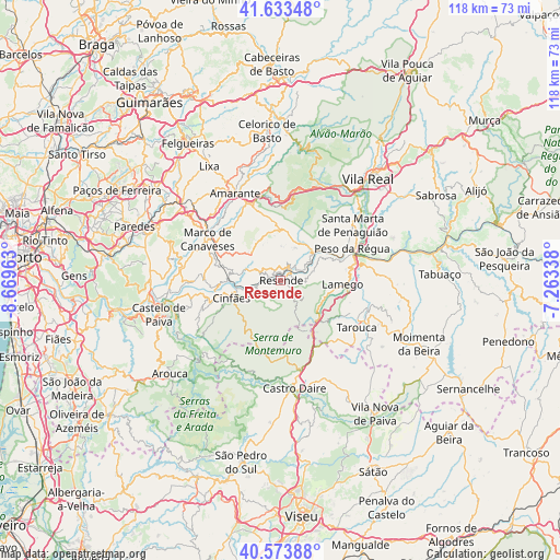
Resende GPS coordinates[2]
41° 6' 20.952" North, 7° 57' 59.4" West
| Map corner | latitude | longitude |
|---|---|---|
| Upper-left | 41.63348°, | -8.66963° |
| Center: | 41.10582°, | -7.9665° |
| Lower-right: | 40.57388°, | -7.26338° |
| Map W x H: | 117.8×117.8 km | = 73.2×73.2mi |
| max Lat: | 42.11337° ⇑25.6% North |
| Resende: | 41.10582° |
| min Lat: | ⇓74.4% South 32.6448° |
| min Long | Resende | max Long |
| -31.17847° | -7.9665° | -6.27308° |
| W 80.3%⇐ | ⇒19.7% E |
Elevation
Elevation of Resende is 232 m = 761 ft, and this is 55 m = 180 ft above average elevation for this country.
| Max E: |
1008 m = 3307 ft | 25.6% |
| Resende | 232 m 761 ft | |
| Avg. | 177 m = 581 ft | |
Min E: |
-128 m = -420 ft | 74.4% |
See also: Portugal elevation on elevation.city.
Geographical zone
Resende is located in North temperate zone (between Tropic of Cancer and the Arctic Circle). Distance of this Northern Tropic circle is 1964.6 km =1220.7 mi to South.| Distance of | km | miles | from Resende |
|---|---|---|---|
| North Pole | 5436.5 | 3378.1 | to North |
| Arctic Circle | 2830.6 | 1758.9 | to North |
| Tropic Cancer | 1964.6 | 1220.7 | to South |
| Equator | 4570.5 | 2840 | to South |


Nearby cities:
15 places around Resende: (largest is in red/bold)
• Baião
8.5 km =5.3 mi,  317°
317°
• Britiande
15.3 km =9.5 mi,  108°
108°
• Cinfães
11 km =6.8 mi,  250°
250°
• Fontelo
19.9 km =12.4 mi,  85°
85°
• Godim
15.5 km =9.6 mi,  62°
62°
• Lalim
14.6 km =9.1 mi,  120°
120°
• Lamego
13.2 km =8.2 mi, 94°
• Marco de Canavezes
17.5 km =10.9 mi,  299°
299°
• Mesão Frio
8.8 km =5.5 mi,  47°
47°
• Mondim da Beira
20.9 km =13 mi, 117°
• Peso da Régua
16.4 km =10.2 mi,  66°
66°
• Santa Marta de Penaguião
19.2 km =11.9 mi, 52°
• Santo Izidoro
18.8 km =11.7 mi,  308°
308°
• Tarouca
18.8 km =11.7 mi, 121°
• Valadares
4.8 km =3 mi,  345°
345°
Sources, notices
• [Note1] Compared only with cities in Portugal existing in our database
• [Src1] Map data: © OpenStreetMap contributors (CC-BY-SA)
• [Src2] Other city data from geonames.org with taken over terms of usage.
• [Src3] Geographical zone / Annual Mean Temperature by Robert A. Rohde @ Wikipedia
