Fontelo geodata
Fontelo (Viseu) is a populated place; located in Portugal in Europe/Lisbon (GMT+1) time zone. With population of 641 people, there are 803 cities with bigger population in this country. Compared to other cities in Portugal, 75% of cities are located further ↓South; 87.2% of cities are located further ←West and 93.9% of cities have lower elevation than Fontelo. Note1


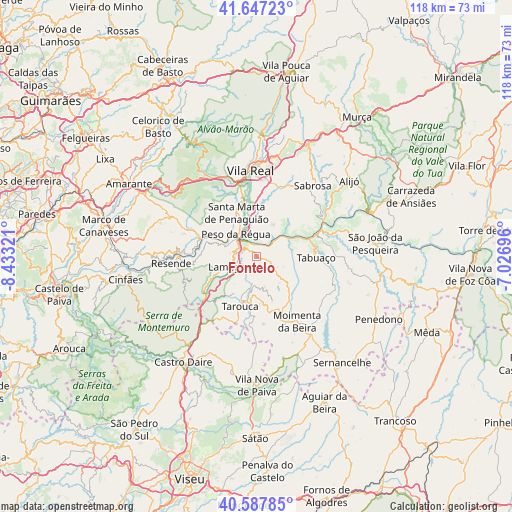
Fontelo GPS coordinates[2]
41° 7' 10.848" North, 7° 43' 48.324" West
| Map corner | latitude | longitude |
|---|---|---|
| Upper-left | 41.64723°, | -8.43321° |
| Center: | 41.11968°, | -7.73009° |
| Lower-right: | 40.58785°, | -7.02696° |
| Map W x H: | 117.8×117.8 km | = 73.2×73.2mi |
| max Lat: | 42.11337° ⇑25% North |
| Fontelo: | 41.11968° |
| min Lat: | ⇓75% South 32.6448° |
| min Long | Fontelo | max Long |
| -31.17847° | -7.73009° | -6.27308° |
| W 87.2%⇐ | ⇒12.8% E |
Elevation
Elevation of Fontelo is 572 m = 1877 ft, and this is 395 m = 1296 ft above average elevation for this country.
| Max E: |
1008 m = 3307 ft | 6.1% |
| Fontelo | 572 m 1877 ft | |
| Avg. | 177 m = 581 ft | |
Min E: |
-128 m = -420 ft | 93.9% |
See also: Portugal elevation on elevation.city.
Geographical zone
Fontelo is located in North temperate zone (between Tropic of Cancer and the Arctic Circle). Distance of this Northern Tropic circle is 1966.2 km =1221.7 mi to South.| Distance of | km | miles | from Fontelo |
|---|---|---|---|
| North Pole | 5435 | 3377.2 | to North |
| Arctic Circle | 2829.1 | 1757.9 | to North |
| Tropic Cancer | 1966.2 | 1221.7 | to South |
| Equator | 4572.1 | 2841 | to South |


Nearby cities:
15 places around Fontelo: (largest is in red/bold)
• Armamar
3.5 km =2.2 mi,  112°
112°
• Britiande
8.2 km =5.1 mi,  219°
219°
• Godim
8.4 km =5.2 mi,  313°
313°
• Lalim
11.5 km =7.1 mi, 218°
• Lamego
7.1 km =4.4 mi,  249°
249°
• Mesão Frio
14.1 km =8.8 mi,  288°
288°
• Moimenta da Beira
17.8 km =11.1 mi,  148°
148°
• Mondim da Beira
11.2 km =7 mi,  186°
186°
• Peso da Régua
6.9 km =4.3 mi,  316°
316°
• Pinhão
17.4 km =10.8 mi,  63°
63°
• Resende
19.9 km =12.4 mi,  265°
265°
• Santa Marta de Penaguião
11 km =6.8 mi,  335°
335°
• Tabuaço
13.6 km =8.5 mi,  91°
91°
• Tarouca
12 km =7.5 mi,  198°
198°
• Vilela
15.8 km =9.8 mi,  42°
42°
Sources, notices
• [Note1] Compared only with cities in Portugal existing in our database
• [Src1] Map data: © OpenStreetMap contributors (CC-BY-SA)
• [Src2] Other city data from geonames.org with taken over terms of usage.
• [Src3] Geographical zone / Annual Mean Temperature by Robert A. Rohde @ Wikipedia
