Mesão Frio geodata
Mesão Frio (Vila Real) is a seat of a second-order administrative division; located in Portugal in Europe/Lisbon (GMT+1) time zone. With population of 4,433 people, there are 480 cities with bigger population in this country. Compared to other cities in Portugal, 76.4% of cities are located further ↓South; 82.9% of cities are located further ←West and 81.9% of cities have lower elevation than Mesão Frio. Note1
Administrative division(s):
- Level 1: Vila Real
- Level 2: Mesão Frio
- Level 3: Mesão Frio (Santa Cristina)


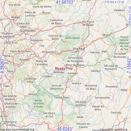
Mesão Frio GPS coordinates[2]
41° 9' 35.28" North, 7° 53' 22.344" West
| Map corner | latitude | longitude |
|---|---|---|
| Upper-left | 41.68703°, | -8.59267° |
| Center: | 41.1598°, | -7.88954° |
| Lower-right: | 40.6283°, | -7.18642° |
| Map W x H: | 117.7×117.7 km | = 73.1×73.1mi |
| max Lat: | 42.11337° ⇑23.6% North |
| Mesão Frio: | 41.1598° |
| min Lat: | ⇓76.4% South 32.6448° |
| min Long | Mesão Frio | max Long |
| -31.17847° | -7.88954° | -6.27308° |
| W 82.9%⇐ | ⇒17.1% E |
Elevation
Elevation of Mesão Frio is 309 m = 1014 ft, and this is 132 m = 433 ft above average elevation for this country.
| Max E: |
1008 m = 3307 ft | 18.1% |
| Mesão Frio | 309 m 1014 ft | |
| Avg. | 177 m = 581 ft | |
Min E: |
-128 m = -420 ft | 81.9% |
See also: Portugal elevation on elevation.city.
Geographical zone
Mesão Frio is located in North temperate zone (between Tropic of Cancer and the Arctic Circle). Distance of this Northern Tropic circle is 1970.6 km =1224.5 mi to South.| Distance of | km | miles | from Mesão Frio |
|---|---|---|---|
| North Pole | 5430.5 | 3374.4 | to North |
| Arctic Circle | 2824.6 | 1755.1 | to North |
| Tropic Cancer | 1970.6 | 1224.5 | to South |
| Equator | 4576.5 | 2843.7 | to South |


Nearby cities:
15 places around Mesão Frio: (largest is in red/bold)
• Armamar
17.6 km =10.9 mi,  109°
109°
• Baião
12.2 km =7.6 mi,  271°
271°
• Britiande
13.5 km =8.4 mi,  142°
142°
• Cinfães
19.4 km =12.1 mi,  239°
239°
• Fontelo
14.1 km =8.8 mi, 108°
• Godim
7.3 km =4.5 mi,  80°
80°
• Lalim
14.7 km =9.1 mi,  155°
155°
• Lamego
9.6 km =6 mi, 136°
• Mondim da Beira
19.7 km =12.2 mi, 142°
• Peso da Régua
8.6 km =5.3 mi,  86°
86°
• Resende
8.8 km =5.5 mi,  227°
227°
• Santa Marta de Penaguião
10.5 km =6.5 mi,  57°
57°
• Tarouca
18.5 km =11.5 mi,  148°
148°
• Valadares
7.8 km =4.8 mi,  259°
259°
• Vila Real
19.8 km =12.3 mi,  37°
37°
Sources, notices
• [Note1] Compared only with cities in Portugal existing in our database
• [Src1] Map data: © OpenStreetMap contributors (CC-BY-SA)
• [Src2] Other city data from geonames.org with taken over terms of usage.
• [Src3] Geographical zone / Annual Mean Temperature by Robert A. Rohde @ Wikipedia
