Valadares geodata
Valadares (Porto) is a populated place; located in Portugal in Europe/Lisbon (GMT+1) time zone. With population of 9,255 people, there are 237 cities with bigger population in this country. Compared to other cities in Portugal, 75.8% of cities are located further ↓South; 80% of cities are located further ←West and 94.1% of cities have lower elevation than Valadares. Note1


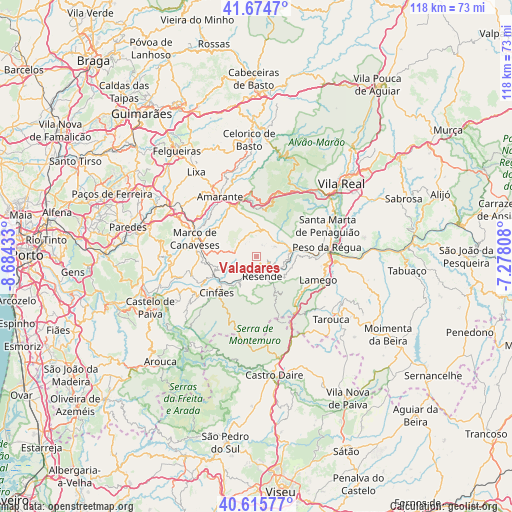
Valadares GPS coordinates[2]
41° 8' 50.532" North, 7° 58' 52.32" West
| Map corner | latitude | longitude |
|---|---|---|
| Upper-left | 41.6747°, | -8.68433° |
| Center: | 41.14737°, | -7.9812° |
| Lower-right: | 40.61577°, | -7.27808° |
| Map W x H: | 117.7×117.7 km | = 73.1×73.1mi |
| max Lat: | 42.11337° ⇑24.2% North |
| Valadares: | 41.14737° |
| min Lat: | ⇓75.8% South 32.6448° |
| min Long | Valadares | max Long |
| -31.17847° | -7.9812° | -6.27308° |
| W 80%⇐ | ⇒20% E |
Elevation
Elevation of Valadares is 574 m = 1883 ft, and this is 397 m = 1302 ft above average elevation for this country.
| Max E: |
1008 m = 3307 ft | 5.9% |
| Valadares | 574 m 1883 ft | |
| Avg. | 177 m = 581 ft | |
Min E: |
-128 m = -420 ft | 94.1% |
See also: Portugal elevation on elevation.city.
Geographical zone
Valadares is located in North temperate zone (between Tropic of Cancer and the Arctic Circle). Distance of this Northern Tropic circle is 1969.2 km =1223.6 mi to South.| Distance of | km | miles | from Valadares |
|---|---|---|---|
| North Pole | 5431.9 | 3375.2 | to North |
| Arctic Circle | 2826 | 1756 | to North |
| Tropic Cancer | 1969.2 | 1223.6 | to South |
| Equator | 4575.2 | 2842.9 | to South |


Nearby cities:
15 places around Valadares: (largest is in red/bold)
• Amarante
16.3 km =10.1 mi,  328°
328°
• Baião
4.8 km =3 mi,  290°
290°
• Britiande
18.4 km =11.4 mi,  120°
120°
• Cinfães
12.4 km =7.7 mi,  227°
227°
• Godim
15.1 km =9.4 mi,  79°
79°
• Lalim
18.3 km =11.4 mi,  130°
130°
• Lamego
15.4 km =9.6 mi,  111°
111°
• Marco de Canavezes
14.6 km =9.1 mi, 286°
• Mesão Frio
7.8 km =4.8 mi, 79°
• Peso da Régua
16.4 km =10.2 mi, 83°
• Resende
4.8 km =3 mi,  165°
165°
• Santa Marta de Penaguião
17.9 km =11.1 mi,  67°
67°
• Santo Izidoro
15.2 km =9.4 mi,  297°
297°
• Telões
21.1 km =13.1 mi, 329°
• Vila Meã
20.5 km =12.7 mi, 304°
Sources, notices
• [Note1] Compared only with cities in Portugal existing in our database
• [Src1] Map data: © OpenStreetMap contributors (CC-BY-SA)
• [Src2] Other city data from geonames.org with taken over terms of usage.
• [Src3] Geographical zone / Annual Mean Temperature by Robert A. Rohde @ Wikipedia
