Godim geodata
Godim (Vila Real) is a populated place; located in Portugal in Europe/Lisbon (GMT+1) time zone. With population of 4,919 people, there are 433 cities with bigger population in this country. Compared to other cities in Portugal, 76.9% of cities are located further ↓South; 84.7% of cities are located further ←West and 51.1% of cities have lower elevation than Godim. Note1


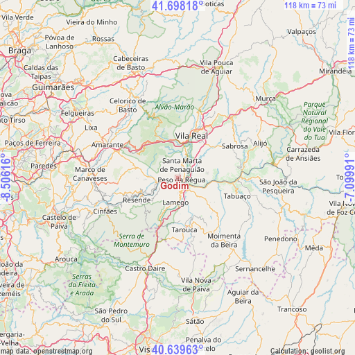
Godim GPS coordinates[2]
41° 10' 15.744" North, 7° 48' 10.908" West
| Map corner | latitude | longitude |
|---|---|---|
| Upper-left | 41.69818°, | -8.50616° |
| Center: | 41.17104°, | -7.80303° |
| Lower-right: | 40.63963°, | -7.09991° |
| Map W x H: | 117.7×117.7 km | = 73.1×73.1mi |
| max Lat: | 42.11337° ⇑23.1% North |
| Godim: | 41.17104° |
| min Lat: | ⇓76.9% South 32.6448° |
| min Long | Godim | max Long |
| -31.17847° | -7.80303° | -6.27308° |
| W 84.7%⇐ | ⇒15.3% E |
Elevation
Elevation of Godim is 117 m = 384 ft, and this is 60 m = 197 ft below average elevation for this country.
| Max E: |
1008 m = 3307 ft | 48.9% |
| Avg. | 177 m = 581 ft | |
| Godim | 117 m = 384 ft | |
Min E: |
-128 m = -420 ft | 51.1% |
See also: Portugal elevation on elevation.city.
Geographical zone
Godim is located in North temperate zone (between Tropic of Cancer and the Arctic Circle). Distance of this Northern Tropic circle is 1971.9 km =1225.3 mi to South.| Distance of | km | miles | from Godim |
|---|---|---|---|
| North Pole | 5429.3 | 3373.6 | to North |
| Arctic Circle | 2823.4 | 1754.4 | to North |
| Tropic Cancer | 1971.9 | 1225.3 | to South |
| Equator | 4577.8 | 2844.5 | to South |


Nearby cities:
15 places around Godim: (largest is in red/bold)
• Armamar
11.7 km =7.3 mi,  127°
127°
• Baião
19.4 km =12.1 mi,  267°
267°
• Britiande
12.1 km =7.5 mi,  175°
175°
• Fontelo
8.4 km =5.2 mi, 133°
• Lalim
14.7 km =9.1 mi, 184°
• Lamego
8.2 km =5.1 mi, 184°
• Mesão Frio
7.3 km =4.5 mi,  260°
260°
• Mondim da Beira
17.5 km =10.9 mi,  164°
164°
• Peso da Régua
1.5 km =0.9 mi,  116°
116°
• Resende
15.5 km =9.6 mi,  242°
242°
• Santa Marta de Penaguião
4.6 km =2.9 mi,  20°
20°
• Tarouca
17.2 km =10.7 mi,  172°
172°
• Valadares
15.1 km =9.4 mi, 259°
• Vila Real
15.2 km =9.4 mi, 18°
• Vilela
17.8 km =11.1 mi,  70°
70°
Sources, notices
• [Note1] Compared only with cities in Portugal existing in our database
• [Src1] Map data: © OpenStreetMap contributors (CC-BY-SA)
• [Src2] Other city data from geonames.org with taken over terms of usage.
• [Src3] Geographical zone / Annual Mean Temperature by Robert A. Rohde @ Wikipedia
