Montalegre geodata
Montalegre (Vila Real) is a seat of a second-order administrative division; located in Portugal in Europe/Lisbon (GMT+1) time zone. In our database, there are 824 cities with bigger population. Compared to other cities in Portugal, 98.8% of cities are located further ↓South; 85.4% of cities are located further ←West and 99.9% of cities have lower elevation than Montalegre. Note1


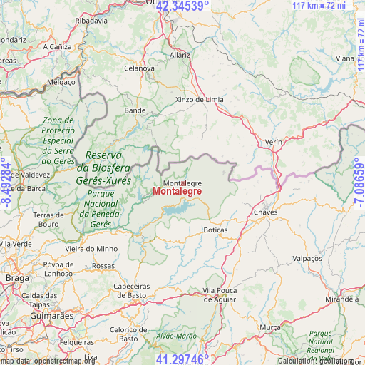
Montalegre GPS coordinates[2]
41° 49' 24.852" North, 7° 47' 22.956" West
| Map corner | latitude | longitude |
|---|---|---|
| Upper-left | 42.34539°, | -8.49284° |
| Center: | 41.82357°, | -7.78971° |
| Lower-right: | 41.29746°, | -7.08659° |
| Map W x H: | 116.5×116.5 km | = 72.4×72.4mi |
| max Lat: | 42.11337° ⇑1.2% North |
| Montalegre: | 41.82357° |
| min Lat: | ⇓98.8% South 32.6448° |
| min Long | Montalegre | max Long |
| -31.17847° | -7.78971° | -6.27308° |
| W 85.4%⇐ | ⇒14.6% E |
Elevation
Elevation of Montalegre is 996 m = 3268 ft, and this is 819 m = 2687 ft above average elevation for this country.
| Max E: |
1008 m = 3307 ft | 0.099999999999994% |
| Montalegre | 996 m 3268 ft | |
| Avg. | 177 m = 581 ft | |
Min E: |
-128 m = -420 ft | 99.9% |
See also: Portugal elevation on elevation.city.
Geographical zone
Montalegre is located in North temperate zone (between Tropic of Cancer and the Arctic Circle). Distance of this Northern Tropic circle is 2044.4 km =1270.3 mi to South.| Distance of | km | miles | from Montalegre |
|---|---|---|---|
| North Pole | 5356.7 | 3328.5 | to North |
| Arctic Circle | 2750.8 | 1709.3 | to North |
| Tropic Cancer | 2044.4 | 1270.3 | to South |
| Equator | 4650.3 | 2889.6 | to South |


Nearby cities:
15 places around Montalegre: (largest is in red/bold)
• Alvito
40.3 km =25 mi,  206°
206°
• Boticas
18 km =11.2 mi,  146°
146°
• Cabeceiras de Basto
38.2 km =23.7 mi, 205°
• Chaves
28.2 km =17.5 mi,  109°
109°
• Goães
46.8 km =29.1 mi,  246°
246°
• Mondim de Basto
47.8 km =29.7 mi,  196°
196°
• Refojos de Basto
38.5 km =23.9 mi, 206°
• Ribeira de Pena
33.6 km =20.9 mi,  181°
181°
• Santa Cruz
27.6 km =17.1 mi,  104°
104°
• Sobreira
33.4 km =20.8 mi, 181°
• Terras de Bouro
44.6 km =27.7 mi, 254°
• Valpaços
46.4 km =28.8 mi,  121°
121°
• Vieira do Minho
36.1 km =22.4 mi,  234°
234°
• Vila
38.2 km =23.7 mi,  306°
306°
• Vila Pouca de Aguiar
37.9 km =23.5 mi,  161°
161°
Sources, notices
• [Note1] Compared only with cities in Portugal existing in our database
• [Src1] Map data: © OpenStreetMap contributors (CC-BY-SA)
• [Src2] Other city data from geonames.org with taken over terms of usage.
• [Src3] Geographical zone / Annual Mean Temperature by Robert A. Rohde @ Wikipedia
