Chaves geodata
Chaves (Vila Real) is a seat of a second-order administrative division; located in Portugal in Europe/Lisbon (GMT+1) time zone. With population of 17,535 people, there are 118 cities with bigger population in this country. Compared to other cities in Portugal, 97.9% of cities are located further ↓South; 93.1% of cities are located further ←West and 85.2% of cities have lower elevation than Chaves. Note1


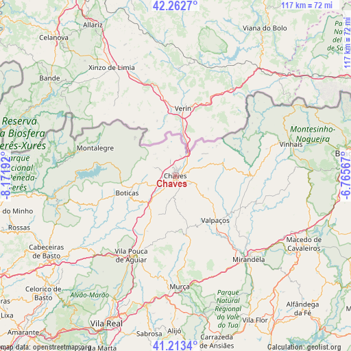
Chaves GPS coordinates[2]
41° 44' 24.684" North, 7° 28' 7.644" West
| Map corner | latitude | longitude |
|---|---|---|
| Upper-left | 42.2627°, | -8.17192° |
| Center: | 41.74019°, | -7.46879° |
| Lower-right: | 41.2134°, | -6.76567° |
| Map W x H: | 116.7×116.7 km | = 72.5×72.5mi |
| max Lat: | 42.11337° ⇑2.1% North |
| Chaves: | 41.74019° |
| min Lat: | ⇓97.9% South 32.6448° |
| min Long | Chaves | max Long |
| -31.17847° | -7.46879° | -6.27308° |
| W 93.1%⇐ | ⇒6.9% E |
Elevation
Elevation of Chaves is 362 m = 1188 ft, and this is 185 m = 607 ft above average elevation for this country.
| Max E: |
1008 m = 3307 ft | 14.8% |
| Chaves | 362 m 1188 ft | |
| Avg. | 177 m = 581 ft | |
Min E: |
-128 m = -420 ft | 85.2% |
See also: Portugal elevation on elevation.city.
Geographical zone
Chaves is located in North temperate zone (between Tropic of Cancer and the Arctic Circle). Distance of this Northern Tropic circle is 2035.2 km =1264.6 mi to South.| Distance of | km | miles | from Chaves |
|---|---|---|---|
| North Pole | 5366 | 3334.3 | to North |
| Arctic Circle | 2760.1 | 1715 | to North |
| Tropic Cancer | 2035.2 | 1264.6 | to South |
| Equator | 4641.1 | 2883.8 | to South |


Nearby cities:
15 places around Chaves: (largest is in red/bold)
• Alijó
51.6 km =32.1 mi,  180°
180°
• Alvito
52 km =32.3 mi,  238°
238°
• Boticas
17.6 km =10.9 mi,  251°
251°
• Cabeceiras de Basto
50 km =31.1 mi, 239°
• Macedo de Cavaleiros
47.8 km =29.7 mi,  118°
118°
• Mirandela
36.6 km =22.7 mi,  140°
140°
• Montalegre
28.2 km =17.5 mi,  289°
289°
• Murça
37.2 km =23.1 mi, 178°
• Refojos de Basto
50.5 km =31.4 mi, 240°
• Ribeira de Pena
36.9 km =22.9 mi,  228°
228°
• Santa Cruz
2.2 km =1.4 mi,  0°
0°
• Sobreira
36.7 km =22.8 mi, 229°
• Valpaços
19.7 km =12.2 mi, 138°
• Vila Pouca de Aguiar
30.4 km =18.9 mi,  208°
208°
• Vinhais
39.9 km =24.8 mi,  74°
74°
Sources, notices
• [Note1] Compared only with cities in Portugal existing in our database
• [Src1] Map data: © OpenStreetMap contributors (CC-BY-SA)
• [Src2] Other city data from geonames.org with taken over terms of usage.
• [Src3] Geographical zone / Annual Mean Temperature by Robert A. Rohde @ Wikipedia
