Vila geodata
Vila (Viana do Castelo) is a seat of a third-order administrative division; located in Portugal in Europe/Lisbon (GMT+1) time zone. In our database, there are 824 cities with bigger population. Compared to other cities in Portugal, 99.7% of cities are located further ↓South; 74.9% of cities are located further ←West and 99.8% of cities have lower elevation than Vila. Note1


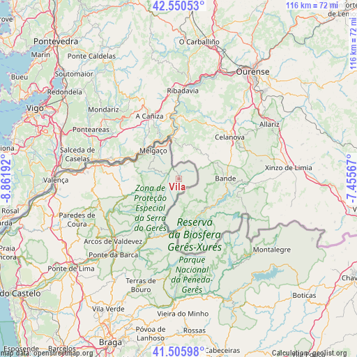
Vila GPS coordinates[2]
42° 1' 49.44" North, 8° 9' 31.68" West
| Map corner | latitude | longitude |
|---|---|---|
| Upper-left | 42.55053°, | -8.86192° |
| Center: | 42.0304°, | -8.1588° |
| Lower-right: | 41.50598°, | -7.45567° |
| Map W x H: | 116.1×116.1 km | = 72.1×72.1mi |
| max Lat: | 42.11337° ⇑0.3% North |
| Vila: | 42.0304° |
| min Lat: | ⇓99.7% South 32.6448° |
| min Long | Vila | max Long |
| -31.17847° | -8.1588° | -6.27308° |
| W 74.9%⇐ | ⇒25.1% E |
Elevation
Elevation of Vila is 945 m = 3100 ft, and this is 768 m = 2520 ft above average elevation for this country.
| Max E: |
1008 m = 3307 ft | 0.2% |
| Vila | 945 m 3100 ft | |
| Avg. | 177 m = 581 ft | |
Min E: |
-128 m = -420 ft | 99.8% |
See also: Portugal elevation on elevation.city.
Geographical zone
Vila is located in North temperate zone (between Tropic of Cancer and the Arctic Circle). Distance of this Northern Tropic circle is 2067.4 km =1284.6 mi to South.| Distance of | km | miles | from Vila |
|---|---|---|---|
| North Pole | 5333.7 | 3314.2 | to North |
| Arctic Circle | 2727.8 | 1695 | to North |
| Tropic Cancer | 2067.4 | 1284.6 | to South |
| Equator | 4673.3 | 2903.9 | to South |


Nearby cities:
15 places around Vila: (largest is in red/bold)
• Aboim da Nóbrega
36.8 km =22.9 mi,  211°
211°
• Arcos de Valdevez
29.7 km =18.5 mi,  226°
226°
• Caldelas
44 km =27.3 mi,  204°
204°
• Goães
43.1 km =26.8 mi, 196°
• Melgaço
12.5 km =7.8 mi,  317°
317°
• Montalegre
38.2 km =23.7 mi,  126°
126°
• Monção
27.1 km =16.8 mi,  281°
281°
• Mozelos
26.8 km =16.7 mi, 227°
• Paredes de Coura
35.8 km =22.2 mi,  248°
248°
• Ponte da Barca
32.9 km =20.4 mi,  220°
220°
• Rubiãis
41.4 km =25.7 mi, 248°
• Sande
41.3 km =25.7 mi, 207°
• Terras de Bouro
36.9 km =22.9 mi, 199°
• Valenza
39.3 km =24.4 mi,  268°
268°
• Valença
40.2 km =25 mi, 270°
Sources, notices
• [Note1] Compared only with cities in Portugal existing in our database
• [Src1] Map data: © OpenStreetMap contributors (CC-BY-SA)
• [Src2] Other city data from geonames.org with taken over terms of usage.
• [Src3] Geographical zone / Annual Mean Temperature by Robert A. Rohde @ Wikipedia
