Boticas geodata
Boticas (Vila Real) is a seat of a second-order administrative division; located in Portugal in Europe/Lisbon (GMT+1) time zone. With population of 5,750 people, there are 377 cities with bigger population in this country. Compared to other cities in Portugal, 97.2% of cities are located further ↓South; 88.5% of cities are located further ←West and 91.1% of cities have lower elevation than Boticas. Note1


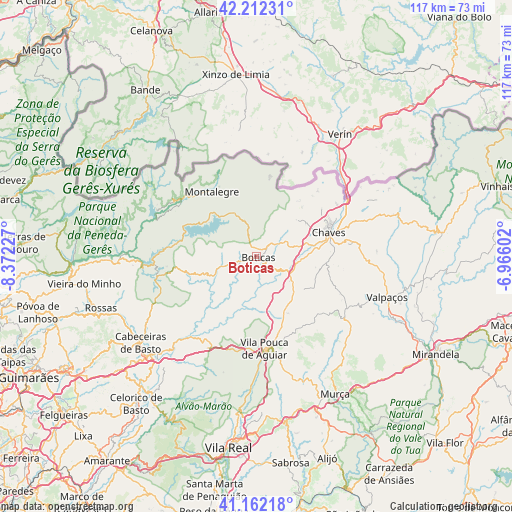
Boticas GPS coordinates[2]
41° 41' 21.804" North, 7° 40' 8.904" West
| Map corner | latitude | longitude |
|---|---|---|
| Upper-left | 42.21231°, | -8.37227° |
| Center: | 41.68939°, | -7.66914° |
| Lower-right: | 41.16218°, | -6.96602° |
| Map W x H: | 116.8×116.8 km | = 72.6×72.6mi |
| max Lat: | 42.11337° ⇑2.8% North |
| Boticas: | 41.68939° |
| min Lat: | ⇓97.2% South 32.6448° |
| min Long | Boticas | max Long |
| -31.17847° | -7.66914° | -6.27308° |
| W 88.5%⇐ | ⇒11.5% E |
Elevation
Elevation of Boticas is 491 m = 1611 ft, and this is 314 m = 1030 ft above average elevation for this country.
| Max E: |
1008 m = 3307 ft | 8.9% |
| Boticas | 491 m 1611 ft | |
| Avg. | 177 m = 581 ft | |
Min E: |
-128 m = -420 ft | 91.1% |
See also: Portugal elevation on elevation.city.
Geographical zone
Boticas is located in North temperate zone (between Tropic of Cancer and the Arctic Circle). Distance of this Northern Tropic circle is 2029.5 km =1261.1 mi to South.| Distance of | km | miles | from Boticas |
|---|---|---|---|
| North Pole | 5371.6 | 3337.8 | to North |
| Arctic Circle | 2765.7 | 1718.5 | to North |
| Tropic Cancer | 2029.5 | 1261.1 | to South |
| Equator | 4635.4 | 2880.3 | to South |


Nearby cities:
15 places around Boticas: (largest is in red/bold)
• Alvito
35 km =21.7 mi,  232°
232°
• Cabeceiras de Basto
33 km =20.5 mi, 233°
• Celorico de Basto
43.5 km =27 mi,  219°
219°
• Chaves
17.6 km =10.9 mi,  71°
71°
• Mondim de Basto
39 km =24.2 mi, 217°
• Montalegre
18 km =11.2 mi,  326°
326°
• Murça
36.2 km =22.5 mi,  150°
150°
• Refojos de Basto
33.4 km =20.8 mi, 234°
• Ribeira de Pena
21.7 km =13.5 mi,  210°
210°
• Santa Cruz
18.4 km =11.4 mi,  64°
64°
• Sobreira
21.5 km =13.4 mi, 211°
• Valpaços
31.1 km =19.3 mi,  107°
107°
• Vieira do Minho
39.8 km =24.7 mi,  260°
260°
• Vila Pouca de Aguiar
21.1 km =13.1 mi,  174°
174°
• Vila Real
43.7 km =27.2 mi,  188°
188°
Sources, notices
• [Note1] Compared only with cities in Portugal existing in our database
• [Src1] Map data: © OpenStreetMap contributors (CC-BY-SA)
• [Src2] Other city data from geonames.org with taken over terms of usage.
• [Src3] Geographical zone / Annual Mean Temperature by Robert A. Rohde @ Wikipedia
