Valpaços geodata
Valpaços (Vila Real) is a seat of a second-order administrative division; located in Portugal in Europe/Lisbon (GMT+1) time zone. With population of 4,573 people, there are 464 cities with bigger population in this country. Compared to other cities in Portugal, 96% of cities are located further ↓South; 96.5% of cities are located further ←West and 88.5% of cities have lower elevation than Valpaços. Note1


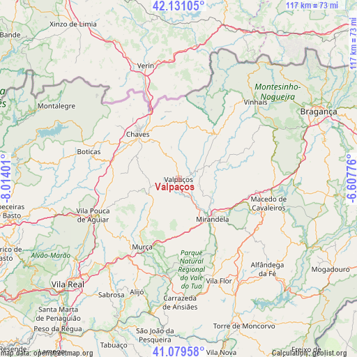
Valpaços GPS coordinates[2]
41° 36' 26.856" North, 7° 18' 39.168" West
| Map corner | latitude | longitude |
|---|---|---|
| Upper-left | 42.13105°, | -8.01401° |
| Center: | 41.60746°, | -7.31088° |
| Lower-right: | 41.07958°, | -6.60776° |
| Map W x H: | 116.9×116.9 km | = 72.6×72.6mi |
| max Lat: | 42.11337° ⇑4% North |
| Valpaços: | 41.60746° |
| min Lat: | ⇓96% South 32.6448° |
| min Long | Valpaços | max Long |
| -31.17847° | -7.31088° | -6.27308° |
| W 96.5%⇐ | ⇒3.5% E |
Elevation
Elevation of Valpaços is 432 m = 1417 ft, and this is 255 m = 837 ft above average elevation for this country.
| Max E: |
1008 m = 3307 ft | 11.5% |
| Valpaços | 432 m 1417 ft | |
| Avg. | 177 m = 581 ft | |
Min E: |
-128 m = -420 ft | 88.5% |
See also: Portugal elevation on elevation.city.
Geographical zone
Valpaços is located in North temperate zone (between Tropic of Cancer and the Arctic Circle). Distance of this Northern Tropic circle is 2020.4 km =1255.4 mi to South.| Distance of | km | miles | from Valpaços |
|---|---|---|---|
| North Pole | 5380.7 | 3343.4 | to North |
| Arctic Circle | 2774.9 | 1724.2 | to North |
| Tropic Cancer | 2020.4 | 1255.4 | to South |
| Equator | 4626.3 | 2874.6 | to South |


Nearby cities:
15 places around Valpaços: (largest is in red/bold)
• Alfândega da Fé
41.4 km =25.7 mi,  135°
135°
• Alijó
39.3 km =24.4 mi,  200°
200°
• Belver
40.2 km =25 mi,  175°
175°
• Boticas
31.1 km =19.3 mi,  287°
287°
• Carrazeda de Anciães
40.6 km =25.2 mi, 179°
• Chaves
19.7 km =12.2 mi,  318°
318°
• Favaios
41 km =25.5 mi, 203°
• Macedo de Cavaleiros
30.1 km =18.7 mi,  104°
104°
• Mirandela
16.9 km =10.5 mi, 142°
• Murça
25.4 km =15.8 mi,  208°
208°
• Santa Cruz
21.4 km =13.3 mi, 322°
• Sobreira
41.9 km =26 mi,  257°
257°
• Vila Flor
35.7 km =22.2 mi,  158°
158°
• Vila Pouca de Aguiar
30.2 km =18.8 mi,  246°
246°
• Vinhais
35.8 km =22.2 mi,  45°
45°
Sources, notices
• [Note1] Compared only with cities in Portugal existing in our database
• [Src1] Map data: © OpenStreetMap contributors (CC-BY-SA)
• [Src2] Other city data from geonames.org with taken over terms of usage.
• [Src3] Geographical zone / Annual Mean Temperature by Robert A. Rohde @ Wikipedia
