Cortegaça geodata
Cortegaça (Aveiro) is a populated place; located in Portugal in Europe/Lisbon (GMT+1) time zone. With population of 4,139 people, there are 507 cities with bigger population in this country. Compared to other cities in Portugal, 69% of cities are located further ↓South; 55% of cities are located further →East and 68.7% of cities have higher elevation than Cortegaça. Note1


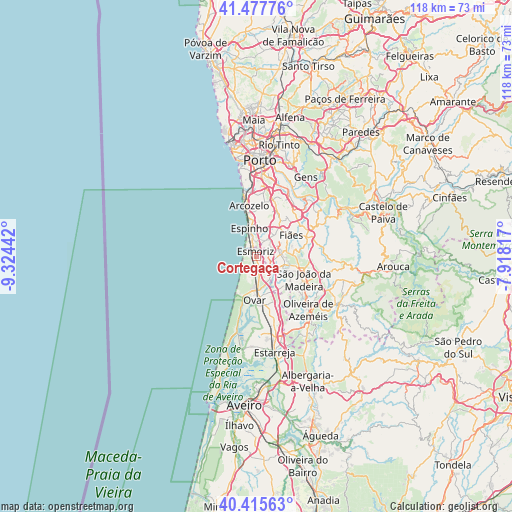
Cortegaça GPS coordinates[2]
40° 56' 55.788" North, 8° 37' 16.68" West
| Map corner | latitude | longitude |
|---|---|---|
| Upper-left | 41.47776°, | -9.32442° |
| Center: | 40.94883°, | -8.6213° |
| Lower-right: | 40.41563°, | -7.91817° |
| Map W x H: | 118.1×118.1 km | = 73.4×73.4mi |
| max Lat: | 42.11337° ⇑31% North |
| Cortegaça: | 40.94883° |
| min Lat: | ⇓69% South 32.6448° |
| min Long | Cortegaça | max Long |
| -31.17847° | -8.6213° | -6.27308° |
| W 45%⇐ | ⇒55% E |
Elevation
Elevation of Cortegaça is 53 m = 174 ft, and this is 124 m = 407 ft below average elevation for this country.
| Max E: |
1008 m = 3307 ft | 68.7% |
| Avg. | 177 m = 581 ft | |
| Cortegaça | 53 m = 174 ft | |
Min E: |
-128 m = -420 ft | 31.3% |
See also: Portugal elevation on elevation.city.
Geographical zone
Cortegaça is located in North temperate zone (between Tropic of Cancer and the Arctic Circle). Distance of this Northern Tropic circle is 1947.2 km =1209.9 mi to South.| Distance of | km | miles | from Cortegaça |
|---|---|---|---|
| North Pole | 5454 | 3389 | to North |
| Arctic Circle | 2848.1 | 1769.7 | to North |
| Tropic Cancer | 1947.2 | 1209.9 | to South |
| Equator | 4553.1 | 2829.2 | to South |


Nearby cities:
15 places around Cortegaça: (largest is in red/bold)
• Esmoriz
1.1 km =0.7 mi,  332°
332°
• Espargo
4.7 km =2.9 mi,  124°
124°
• Espinho
6.7 km =4.2 mi,  345°
345°
• Feira
7.1 km =4.4 mi,  111°
111°
• Lamas
6 km =3.7 mi,  46°
46°
• Lourosa
7.1 km =4.4 mi,  56°
56°
• Mosteirô
9.4 km =5.8 mi,  126°
126°
• Nogueira da Regedoura
6.7 km =4.2 mi,  21°
21°
• Paços de Brandão
4.3 km =2.7 mi, 47°
• Rio Meão
3.8 km =2.4 mi,  74°
74°
• Sanfins
8.3 km =5.2 mi,  104°
104°
• Silvalde
4.8 km =3 mi,  355°
355°
• Souto
4 km =2.5 mi, 359°
• São João
9.1 km =5.7 mi,  172°
172°
• São João de Ver
5.9 km =3.7 mi,  83°
83°
Sources, notices
• [Note1] Compared only with cities in Portugal existing in our database
• [Src1] Map data: © OpenStreetMap contributors (CC-BY-SA)
• [Src2] Other city data from geonames.org with taken over terms of usage.
• [Src3] Geographical zone / Annual Mean Temperature by Robert A. Rohde @ Wikipedia
