Grijó geodata
Grijó (Porto) is a populated place; located in Portugal in Europe/Lisbon (GMT+1) time zone. With population of 10,907 people, there are 201 cities with bigger population in this country. Compared to other cities in Portugal, 71.2% of cities are located further ↓South; 51.5% of cities are located further →East and 55.4% of cities have lower elevation than Grijó. Note1


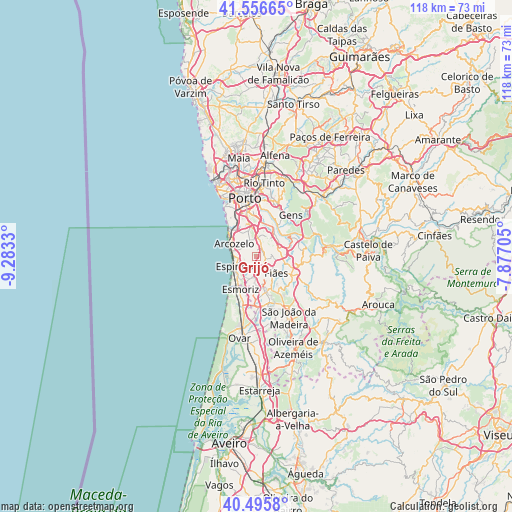
Grijó GPS coordinates[2]
41° 1' 42.096" North, 8° 34' 48.612" West
| Map corner | latitude | longitude |
|---|---|---|
| Upper-left | 41.55665°, | -9.2833° |
| Center: | 41.02836°, | -8.58017° |
| Lower-right: | 40.4958°, | -7.87705° |
| Map W x H: | 118×118 km | = 73.3×73.3mi |
| max Lat: | 42.11337° ⇑28.8% North |
| Grijó: | 41.02836° |
| min Lat: | ⇓71.2% South 32.6448° |
| min Long | Grijó | max Long |
| -31.17847° | -8.58017° | -6.27308° |
| W 48.5%⇐ | ⇒51.5% E |
Elevation
Elevation of Grijó is 130 m = 427 ft, and this is 47 m = 154 ft below average elevation for this country.
| Max E: |
1008 m = 3307 ft | 44.6% |
| Avg. | 177 m = 581 ft | |
| Grijó | 130 m = 427 ft | |
Min E: |
-128 m = -420 ft | 55.4% |
See also: Portugal elevation on elevation.city.
Geographical zone
Grijó is located in North temperate zone (between Tropic of Cancer and the Arctic Circle). Distance of this Northern Tropic circle is 1956 km =1215.4 mi to South.| Distance of | km | miles | from Grijó |
|---|---|---|---|
| North Pole | 5445.1 | 3383.4 | to North |
| Arctic Circle | 2839.2 | 1764.2 | to North |
| Tropic Cancer | 1956 | 1215.4 | to South |
| Equator | 4561.9 | 2834.6 | to South |


Nearby cities:
15 places around Grijó: (largest is in red/bold)
• Arcozelo
5.7 km =3.5 mi,  310°
310°
• Argoncilhe
3.5 km =2.2 mi,  95°
95°
• Espinho
5.6 km =3.5 mi,  245°
245°
• Fiães
5.9 km =3.7 mi,  129°
129°
• Lamas
4.8 km =3 mi,  168°
168°
• Lourosa
5.5 km =3.4 mi,  153°
153°
• Nogueira da Regedoura
2.7 km =1.7 mi,  201°
201°
• Olival
3.9 km =2.4 mi,  51°
51°
• Paços de Brandão
5.9 km =3.7 mi,  182°
182°
• Perozinho
4.1 km =2.5 mi,  353°
353°
• Sermonde
2.1 km =1.3 mi, 350°
• Serzedo
3.9 km =2.4 mi, 309°
• Silvalde
5.6 km =3.5 mi,  223°
223°
• Souto
6 km =3.7 mi, 215°
• São Félix da Marinha
3.6 km =2.2 mi,  282°
282°
Sources, notices
• [Note1] Compared only with cities in Portugal existing in our database
• [Src1] Map data: © OpenStreetMap contributors (CC-BY-SA)
• [Src2] Other city data from geonames.org with taken over terms of usage.
• [Src3] Geographical zone / Annual Mean Temperature by Robert A. Rohde @ Wikipedia
