Souto geodata
Souto (Aveiro) is a populated place; located in Portugal in Europe/Lisbon (GMT+1) time zone. With population of 4,922 people, there are 432 cities with bigger population in this country. Compared to other cities in Portugal, 69.9% of cities are located further ↓South; 55.1% of cities are located further →East and 60.2% of cities have higher elevation than Souto. Note1


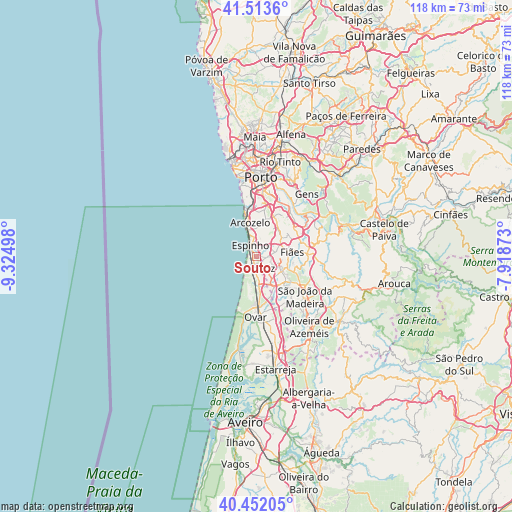
Souto GPS coordinates[2]
40° 59' 5.856" North, 8° 37' 18.66" West
| Map corner | latitude | longitude |
|---|---|---|
| Upper-left | 41.5136°, | -9.32498° |
| Center: | 40.98496°, | -8.62185° |
| Lower-right: | 40.45205°, | -7.91873° |
| Map W x H: | 118×118 km | = 73.3×73.3mi |
| max Lat: | 42.11337° ⇑30.1% North |
| Souto: | 40.98496° |
| min Lat: | ⇓69.9% South 32.6448° |
| min Long | Souto | max Long |
| -31.17847° | -8.62185° | -6.27308° |
| W 44.9%⇐ | ⇒55.1% E |
Elevation
Elevation of Souto is 76 m = 249 ft, and this is 101 m = 331 ft below average elevation for this country.
| Max E: |
1008 m = 3307 ft | 60.2% |
| Avg. | 177 m = 581 ft | |
| Souto | 76 m = 249 ft | |
Min E: |
-128 m = -420 ft | 39.8% |
See also: Portugal elevation on elevation.city.
Geographical zone
Souto is located in North temperate zone (between Tropic of Cancer and the Arctic Circle). Distance of this Northern Tropic circle is 1951.2 km =1212.4 mi to South.| Distance of | km | miles | from Souto |
|---|---|---|---|
| North Pole | 5450 | 3386.5 | to North |
| Arctic Circle | 2844.1 | 1767.2 | to North |
| Tropic Cancer | 1951.2 | 1212.4 | to South |
| Equator | 4557.1 | 2831.6 | to South |


Nearby cities:
15 places around Souto: (largest is in red/bold)
• Cortegaça
4 km =2.5 mi,  179°
179°
• Esmoriz
3.1 km =1.9 mi,  188°
188°
• Espargo
7.8 km =4.8 mi,  149°
149°
• Espinho
3 km =1.9 mi,  327°
327°
• Grijó
6 km =3.7 mi,  35°
35°
• Lamas
4.4 km =2.7 mi,  88°
88°
• Lourosa
5.9 km =3.7 mi, 90°
• Nogueira da Regedoura
3.4 km =2.1 mi,  47°
47°
• Paços de Brandão
3.4 km =2.1 mi,  108°
108°
• Rio Meão
4.8 km =3 mi,  129°
129°
• Sermonde
7.6 km =4.7 mi,  24°
24°
• Serzedo
7.4 km =4.6 mi,  3°
3°
• Silvalde
0.9 km =0.6 mi,  337°
337°
• São Félix da Marinha
5.6 km =3.5 mi,  359°
359°
• São João de Ver
6.8 km =4.2 mi,  119°
119°
Sources, notices
• [Note1] Compared only with cities in Portugal existing in our database
• [Src1] Map data: © OpenStreetMap contributors (CC-BY-SA)
• [Src2] Other city data from geonames.org with taken over terms of usage.
• [Src3] Geographical zone / Annual Mean Temperature by Robert A. Rohde @ Wikipedia
