Castro Daire geodata
Castro Daire (Viseu) is a seat of a second-order administrative division; located in Portugal in Europe/Lisbon (GMT+1) time zone. With population of 4,744 people, there are 449 cities with bigger population in this country. Compared to other cities in Portugal, 67.8% of cities are located further ↓South; 81.1% of cities are located further ←West and 93.8% of cities have lower elevation than Castro Daire. Note1


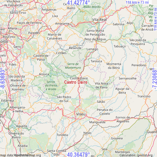
Castro Daire GPS coordinates[2]
40° 53' 54.24" North, 7° 56' 1.716" West
| Map corner | latitude | longitude |
|---|---|---|
| Upper-left | 41.42774°, | -8.63693° |
| Center: | 40.8984°, | -7.93381° |
| Lower-right: | 40.36479°, | -7.23068° |
| Map W x H: | 118.2×118.2 km | = 73.4×73.4mi |
| max Lat: | 42.11337° ⇑32.2% North |
| Castro Daire: | 40.8984° |
| min Lat: | ⇓67.8% South 32.6448° |
| min Long | Castro Daire | max Long |
| -31.17847° | -7.93381° | -6.27308° |
| W 81.1%⇐ | ⇒18.9% E |
Elevation
Elevation of Castro Daire is 571 m = 1873 ft, and this is 394 m = 1293 ft above average elevation for this country.
| Max E: |
1008 m = 3307 ft | 6.2% |
| Castro Daire | 571 m 1873 ft | |
| Avg. | 177 m = 581 ft | |
Min E: |
-128 m = -420 ft | 93.8% |
See also: Portugal elevation on elevation.city.
Geographical zone
Castro Daire is located in North temperate zone (between Tropic of Cancer and the Arctic Circle). Distance of this Northern Tropic circle is 1941.6 km =1206.5 mi to South.| Distance of | km | miles | from Castro Daire |
|---|---|---|---|
| North Pole | 5459.6 | 3392.4 | to North |
| Arctic Circle | 2853.7 | 1773.2 | to North |
| Tropic Cancer | 1941.6 | 1206.5 | to South |
| Equator | 4547.5 | 2825.7 | to South |


Nearby cities:
15 places around Castro Daire: (largest is in red/bold)
• Abraveses
24.2 km =15 mi,  177°
177°
• Arouca
26.4 km =16.4 mi,  277°
277°
• Britiande
21.8 km =13.5 mi,  32°
32°
• Campo
20.9 km =13 mi, 175°
• Cinfães
23.3 km =14.5 mi,  325°
325°
• Lalim
18.5 km =11.5 mi, 32°
• Lamego
24.4 km =15.2 mi, 25°
• Mondim da Beira
20.8 km =12.9 mi,  49°
49°
• Resende
23.2 km =14.4 mi,  353°
353°
• Rio de Loba
26.3 km =16.3 mi,  169°
169°
• Sátão
24.3 km =15.1 mi,  135°
135°
• São Pedro do Sul
19.7 km =12.2 mi,  216°
216°
• Tarouca
18.8 km =11.7 mi, 45°
• Vila Nova de Paiva
18 km =11.2 mi,  106°
106°
• Vouzela
24.6 km =15.3 mi, 217°
Sources, notices
• [Note1] Compared only with cities in Portugal existing in our database
• [Src1] Map data: © OpenStreetMap contributors (CC-BY-SA)
• [Src2] Other city data from geonames.org with taken over terms of usage.
• [Src3] Geographical zone / Annual Mean Temperature by Robert A. Rohde @ Wikipedia
