Castelo de Paiva geodata
Castelo de Paiva (Aveiro) is a seat of a second-order administrative division; located in Portugal in Europe/Lisbon (GMT+1) time zone. In our database, there are 824 cities with bigger population. Compared to other cities in Portugal, 72.4% of cities are located further ↓South; 70.2% of cities are located further ←West and 81.4% of cities have higher elevation than Castelo de Paiva. Note1


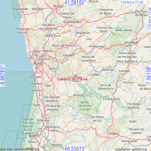
Castelo de Paiva GPS coordinates[2]
41° 3' 46.836" North, 8° 15' 52.92" West
| Map corner | latitude | longitude |
|---|---|---|
| Upper-left | 41.59102°, | -8.96783° |
| Center: | 41.06301°, | -8.2647° |
| Lower-right: | 40.53073°, | -7.56158° |
| Map W x H: | 117.9×117.9 km | = 73.3×73.3mi |
| max Lat: | 42.11337° ⇑27.6% North |
| Castelo de Paiva: | 41.06301° |
| min Lat: | ⇓72.4% South 32.6448° |
| min Long | Castelo de Paiv | max Long |
| -31.17847° | -8.2647° | -6.27308° |
| W 70.2%⇐ | ⇒29.8% E |
Elevation
Elevation of Castelo de Paiva is 31 m = 102 ft, and this is 146 m = 479 ft below average elevation for this country.
| Max E: |
1008 m = 3307 ft | 81.4% |
| Avg. | 177 m = 581 ft | |
| Castelo de Paiva | 31 m = 102 ft | |
Min E: |
-128 m = -420 ft | 18.6% |
See also: Portugal elevation on elevation.city.
Geographical zone
Castelo de Paiva is located in North temperate zone (between Tropic of Cancer and the Arctic Circle). Distance of this Northern Tropic circle is 1959.9 km =1217.8 mi to South.| Distance of | km | miles | from Castelo de Paiva |
|---|---|---|---|
| North Pole | 5441.3 | 3381.1 | to North |
| Arctic Circle | 2835.4 | 1761.8 | to North |
| Tropic Cancer | 1959.9 | 1217.8 | to South |
| Equator | 4565.8 | 2837.1 | to South |


Nearby cities:
15 places around Castelo de Paiva: (largest is in red/bold)
• Alpendurada
3.3 km =2.1 mi,  27°
27°
• Arouca
14.8 km =9.2 mi,  173°
173°
• Baltar
17.7 km =11 mi,  324°
324°
• Castelões de Cepeda
16.6 km =10.3 mi,  339°
339°
• Cinfães
14.7 km =9.1 mi,  86°
86°
• Madalena
18 km =11.2 mi, 341°
• Marco de Canavezes
16.6 km =10.3 mi,  35°
35°
• Melres
11.4 km =7.1 mi,  273°
273°
• Moreira
10.5 km =6.5 mi, 265°
• Paredes
16.7 km =10.4 mi, 340°
• Penafiel
16.2 km =10.1 mi,  354°
354°
• Perafita
13.3 km =8.3 mi,  3°
3°
• Recarei
15.9 km =9.9 mi,  309°
309°
• Rio Mau
8.8 km =5.5 mi,  264°
264°
• Santo Izidoro
19.4 km =12.1 mi, 31°
Sources, notices
• [Note1] Compared only with cities in Portugal existing in our database
• [Src1] Map data: © OpenStreetMap contributors (CC-BY-SA)
• [Src2] Other city data from geonames.org with taken over terms of usage.
• [Src3] Geographical zone / Annual Mean Temperature by Robert A. Rohde @ Wikipedia
