Moreira geodata
Moreira (Porto) is a populated place; located in Portugal in Europe/Lisbon (GMT+1) time zone. With population of 11,336 people, there are 187 cities with bigger population in this country. Compared to other cities in Portugal, 72.1% of cities are located further ↓South; 63.7% of cities are located further ←West and 60.5% of cities have higher elevation than Moreira. Note1


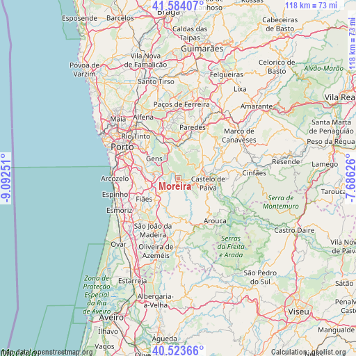
Moreira GPS coordinates[2]
41° 3' 21.6" North, 8° 23' 21.804" West
| Map corner | latitude | longitude |
|---|---|---|
| Upper-left | 41.58407°, | -9.09251° |
| Center: | 41.056°, | -8.38939° |
| Lower-right: | 40.52366°, | -7.68626° |
| Map W x H: | 117.9×117.9 km | = 73.3×73.3mi |
| max Lat: | 42.11337° ⇑27.9% North |
| Moreira: | 41.056° |
| min Lat: | ⇓72.1% South 32.6448° |
| min Long | Moreira | max Long |
| -31.17847° | -8.38939° | -6.27308° |
| W 63.7%⇐ | ⇒36.3% E |
Elevation
Elevation of Moreira is 75 m = 246 ft, and this is 102 m = 335 ft below average elevation for this country.
| Max E: |
1008 m = 3307 ft | 60.5% |
| Avg. | 177 m = 581 ft | |
| Moreira | 75 m = 246 ft | |
Min E: |
-128 m = -420 ft | 39.5% |
See also: Portugal elevation on elevation.city.
Geographical zone
Moreira is located in North temperate zone (between Tropic of Cancer and the Arctic Circle). Distance of this Northern Tropic circle is 1959.1 km =1217.3 mi to South.| Distance of | km | miles | from Moreira |
|---|---|---|---|
| North Pole | 5442.1 | 3381.6 | to North |
| Arctic Circle | 2836.2 | 1762.3 | to North |
| Tropic Cancer | 1959.1 | 1217.3 | to South |
| Equator | 4565 | 2836.6 | to South |


Nearby cities:
15 places around Moreira: (largest is in red/bold)
• Alpendurada
12.5 km =7.8 mi,  72°
72°
• Argoncilhe
13 km =8.1 mi,  254°
254°
• Avintes
14.7 km =9.1 mi,  292°
292°
• Baltar
15.2 km =9.4 mi,  0°
0°
• Castelo de Paiva
10.5 km =6.5 mi,  85°
85°
• Fiães
13.3 km =8.3 mi,  239°
239°
• Foz do Sousa
10.5 km =6.5 mi,  295°
295°
• Jovim
12.5 km =7.8 mi, 299°
• Lobão
11.2 km =7 mi,  226°
226°
• Melres
1.8 km =1.1 mi,  327°
327°
• Olival
13 km =8.1 mi,  267°
267°
• Recarei
11 km =6.8 mi,  350°
350°
• Rio Mau
1.7 km =1.1 mi, 92°
• Sandim
10.1 km =6.3 mi,  256°
256°
• São Pedro da Cova
13.4 km =8.3 mi,  316°
316°
Sources, notices
• [Note1] Compared only with cities in Portugal existing in our database
• [Src1] Map data: © OpenStreetMap contributors (CC-BY-SA)
• [Src2] Other city data from geonames.org with taken over terms of usage.
• [Src3] Geographical zone / Annual Mean Temperature by Robert A. Rohde @ Wikipedia
