Urzelina geodata
Urzelina (Azores) is a populated place; located in Portugal in Atlantic/Azores (GMT+0) time zone. With population of 902 people, there are 767 cities with bigger population in this country. Compared to other cities in Portugal, 77.7% of cities are located further ↑North; 98.4% of cities are located further →East and 62.4% of cities have higher elevation than Urzelina. Note1


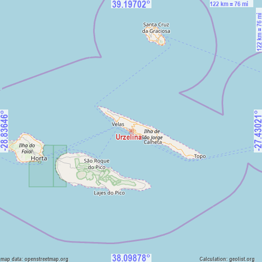
Urzelina GPS coordinates[2]
38° 39' 0" North, 28° 7' 59.988" West
| Map corner | latitude | longitude |
|---|---|---|
| Upper-left | 39.19702°, | -28.83646° |
| Center: | 38.65°, | -28.13333° |
| Lower-right: | 38.09878°, | -27.43021° |
| Map W x H: | 122.1×122.1 km | = 75.9×75.9mi |
| max Lat: | 42.11337° ⇑77.7% North |
| Urzelina: | 38.65° |
| min Lat: | ⇓22.3% South 32.6448° |
| min Long | Urzelina | max Long |
| -31.17847° | -28.13333° | -6.27308° |
| W 1.6%⇐ | ⇒98.4% E |
Elevation
Elevation of Urzelina is 71 m = 233 ft, and this is 106 m = 348 ft below average elevation for this country.
| Max E: |
1008 m = 3307 ft | 62.4% |
| Avg. | 177 m = 581 ft | |
| Urzelina | 71 m = 233 ft | |
Min E: |
-128 m = -420 ft | 37.6% |
See also: Portugal elevation on elevation.city.
Geographical zone
Urzelina is located in North temperate zone (between Tropic of Cancer and the Arctic Circle). Distance of this Northern Tropic circle is 1691.6 km =1051.1 mi to South.| Distance of | km | miles | from Urzelina |
|---|---|---|---|
| North Pole | 5709.6 | 3547.8 | to North |
| Arctic Circle | 3103.7 | 1928.5 | to North |
| Tropic Cancer | 1691.6 | 1051.1 | to South |
| Equator | 4297.5 | 2670.3 | to South |


Nearby cities:
15 places around Urzelina: (largest is in red/bold)
• Angústias
45.4 km =28.2 mi,  252°
252°
• Bandeiras
31.2 km =19.4 mi, 246°
• Cais do Pico
21.4 km =13.3 mi,  229°
229°
• Calheta
11.4 km =7.1 mi,  118°
118°
• Cedros
48.8 km =30.3 mi,  268°
268°
• Horta
44.6 km =27.7 mi, 253°
• Lajes
30.1 km =18.7 mi,  200°
200°
• Madalena
36.4 km =22.6 mi, 249°
• Praia da Graciosa
46.8 km =29.1 mi,  17°
17°
• Ribeira Seca
14.2 km =8.8 mi,  113°
113°
• Rosais
12.5 km =7.8 mi,  306°
306°
• Santa Cruz da Graciosa
49.7 km =30.9 mi,  12°
12°
• Santo Antão
31 km =19.3 mi, 111°
• São Roque do Pico
21.2 km =13.2 mi, 225°
• Velas
7.5 km =4.7 mi,  298°
298°
Sources, notices
• [Note1] Compared only with cities in Portugal existing in our database
• [Src1] Map data: © OpenStreetMap contributors (CC-BY-SA)
• [Src2] Other city data from geonames.org with taken over terms of usage.
• [Src3] Geographical zone / Annual Mean Temperature by Robert A. Rohde @ Wikipedia
