Rosais geodata
Rosais (Azores) is a populated place; located in Portugal in Atlantic/Azores (GMT+0) time zone. With population of 743 people, there are 793 cities with bigger population in this country. Compared to other cities in Portugal, 73.1% of cities are located further ↑North; 98.6% of cities are located further →East and 74.3% of cities have lower elevation than Rosais. Note1


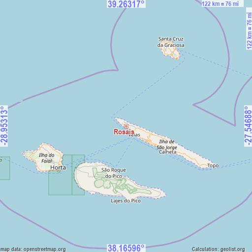
Rosais GPS coordinates[2]
38° 43' 0.012" North, 28° 15' 0" West
| Map corner | latitude | longitude |
|---|---|---|
| Upper-left | 39.26317°, | -28.95313° |
| Center: | 38.71667°, | -28.25° |
| Lower-right: | 38.16596°, | -27.54688° |
| Map W x H: | 122×122 km | = 75.8×75.8mi |
| max Lat: | 42.11337° ⇑73.1% North |
| Rosais: | 38.71667° |
| min Lat: | ⇓26.9% South 32.6448° |
| min Long | Rosais | max Long |
| -31.17847° | -28.25° | -6.27308° |
| W 1.4%⇐ | ⇒98.6% E |
Elevation
Elevation of Rosais is 231 m = 758 ft, and this is 54 m = 177 ft above average elevation for this country.
| Max E: |
1008 m = 3307 ft | 25.7% |
| Rosais | 231 m 758 ft | |
| Avg. | 177 m = 581 ft | |
Min E: |
-128 m = -420 ft | 74.3% |
See also: Portugal elevation on elevation.city.
Geographical zone
Rosais is located in North temperate zone (between Tropic of Cancer and the Arctic Circle). Distance of this Northern Tropic circle is 1699 km =1055.7 mi to South.| Distance of | km | miles | from Rosais |
|---|---|---|---|
| North Pole | 5702.2 | 3543.2 | to North |
| Arctic Circle | 3096.3 | 1924 | to North |
| Tropic Cancer | 1699 | 1055.7 | to South |
| Equator | 4304.9 | 2674.9 | to South |


Nearby cities:
15 places around Rosais: (largest is in red/bold)
• Angústias
39.4 km =24.5 mi,  237°
237°
• Bandeiras
27.1 km =16.8 mi,  223°
223°
• Cais do Pico
22.1 km =13.7 mi,  196°
196°
• Calheta
23.9 km =14.9 mi,  122°
122°
• Cedros
39.6 km =24.6 mi,  256°
256°
• Horta
38.3 km =23.8 mi, 238°
• Lajes
35.7 km =22.2 mi,  180°
180°
• Madalena
31.3 km =19.4 mi,  230°
230°
• Praia da Graciosa
44.4 km =27.6 mi,  32°
32°
• Ribeira Grande
45 km =28 mi, 240°
• Ribeira Seca
26.5 km =16.5 mi, 119°
• Santo Antão
43.3 km =26.9 mi, 115°
• São Roque do Pico
22.8 km =14.2 mi,  192°
192°
• Urzelina
12.5 km =7.8 mi,  126°
126°
• Velas
5.3 km =3.3 mi,  137°
137°
Sources, notices
• [Note1] Compared only with cities in Portugal existing in our database
• [Src1] Map data: © OpenStreetMap contributors (CC-BY-SA)
• [Src2] Other city data from geonames.org with taken over terms of usage.
• [Src3] Geographical zone / Annual Mean Temperature by Robert A. Rohde @ Wikipedia
