Horta geodata
Horta (Azores) is a populated place; located in Portugal in Atlantic/Azores (GMT+0) time zone. With population of 6,572 people, there are 336 cities with bigger population in this country. Compared to other cities in Portugal, 80.3% of cities are located further ↑North; 99.3% of cities are located further →East and 99.9% of cities have higher elevation than Horta. Note1


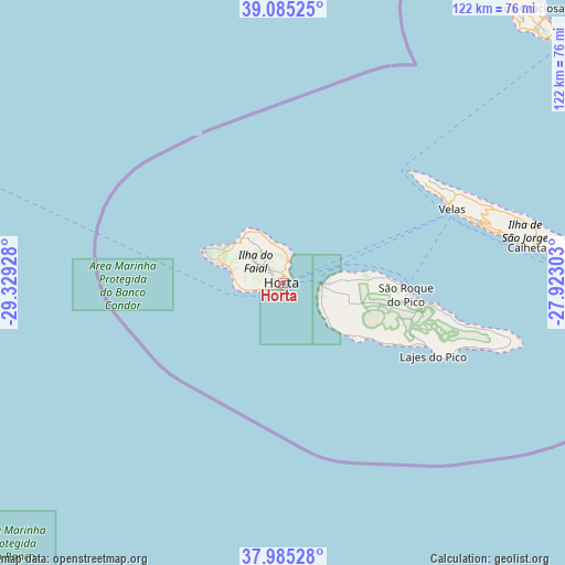
Horta GPS coordinates[2]
38° 32' 14.532" North, 28° 37' 34.14" West
| Map corner | latitude | longitude |
|---|---|---|
| Upper-left | 39.08525°, | -29.32928° |
| Center: | 38.53737°, | -28.62615° |
| Lower-right: | 37.98528°, | -27.92303° |
| Map W x H: | 122.3×122.3 km | = 76×76mi |
| max Lat: | 42.11337° ⇑80.3% North |
| Horta: | 38.53737° |
| min Lat: | ⇓19.7% South 32.6448° |
| min Long | Horta | max Long |
| -31.17847° | -28.62615° | -6.27308° |
| W 0.7%⇐ | ⇒99.3% E |
Elevation
Elevation of Horta is 1 m = 3 ft, and this is 176 m = 577 ft below average elevation for this country.
| Max E: |
1008 m = 3307 ft | 99.9% |
| Avg. | 177 m = 581 ft | |
| Horta | 1 m = 3 ft | |
Min E: |
-128 m = -420 ft | 0.1% |
See also: Portugal elevation on elevation.city.
Geographical zone
Horta is located in North temperate zone (between Tropic of Cancer and the Arctic Circle). Distance of this Northern Tropic circle is 1679 km =1043.3 mi to South.| Distance of | km | miles | from Horta |
|---|---|---|---|
| North Pole | 5722.1 | 3555.5 | to North |
| Arctic Circle | 3116.2 | 1936.3 | to North |
| Tropic Cancer | 1679 | 1043.3 | to South |
| Equator | 4285 | 2662.6 | to South |


Nearby cities:
15 places around Horta: (largest is in red/bold)
• Angústias
1.4 km =0.9 mi,  198°
198°
• Bandeiras
14.2 km =8.8 mi,  89°
89°
• Cais do Pico
26.6 km =16.5 mi, 92°
• Calheta
53.4 km =33.2 mi,  82°
82°
• Castelo Branco
7.8 km =4.8 mi,  257°
257°
• Cedros
12.4 km =7.7 mi,  331°
331°
• Lajes
36.2 km =22.5 mi,  115°
115°
• Madalena
8.7 km =5.4 mi, 90°
• Ribeira Grande
6.8 km =4.2 mi,  250°
250°
• Ribeira Seca
56.3 km =35 mi, 82°
• Rosais
38.3 km =23.8 mi,  58°
58°
• Santo Antão
71.9 km =44.7 mi, 88°
• São Roque do Pico
27.8 km =17.3 mi, 94°
• Urzelina
44.6 km =27.7 mi,  73°
73°
• Velas
39.6 km =24.6 mi, 66°
Sources, notices
• [Note1] Compared only with cities in Portugal existing in our database
• [Src1] Map data: © OpenStreetMap contributors (CC-BY-SA)
• [Src2] Other city data from geonames.org with taken over terms of usage.
• [Src3] Geographical zone / Annual Mean Temperature by Robert A. Rohde @ Wikipedia
