Castelo Branco geodata
Castelo Branco (Azores) is a populated place; located in Portugal in Atlantic/Azores (GMT+0) time zone. With population of 1,309 people, there are 710 cities with bigger population in this country. Compared to other cities in Portugal, 80.9% of cities are located further ↑North; 99.8% of cities are located further →East and 71.6% of cities have higher elevation than Castelo Branco. Note1


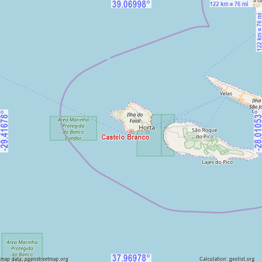
Castelo Branco GPS coordinates[2]
38° 31' 19.128" North, 28° 42' 49.14" West
| Map corner | latitude | longitude |
|---|---|---|
| Upper-left | 39.06998°, | -29.41678° |
| Center: | 38.52198°, | -28.71365° |
| Lower-right: | 37.96978°, | -28.01053° |
| Map W x H: | 122.3×122.3 km | = 76×76mi |
| max Lat: | 42.11337° ⇑80.9% North |
| Castelo Branco: | 38.52198° |
| min Lat: | ⇓19.1% South 32.6448° |
| min Long | Castelo Branco | max Long |
| -31.17847° | -28.71365° | -6.27308° |
| W 0.2%⇐ | ⇒99.8% E |
Elevation
Elevation of Castelo Branco is 47 m = 154 ft, and this is 130 m = 427 ft below average elevation for this country.
| Max E: |
1008 m = 3307 ft | 71.6% |
| Avg. | 177 m = 581 ft | |
| Castelo Branco | 47 m = 154 ft | |
Min E: |
-128 m = -420 ft | 28.4% |
See also: Portugal elevation on elevation.city.
Geographical zone
Castelo Branco is located in North temperate zone (between Tropic of Cancer and the Arctic Circle). Distance of this Northern Tropic circle is 1677.3 km =1042.2 mi to South.| Distance of | km | miles | from Castelo Branco |
|---|---|---|---|
| North Pole | 5723.8 | 3556.6 | to North |
| Arctic Circle | 3117.9 | 1937.4 | to North |
| Tropic Cancer | 1677.3 | 1042.2 | to South |
| Equator | 4283.2 | 2661.5 | to South |


Nearby cities:
15 places around Castelo Branco: (largest is in red/bold)
• Angústias
7.2 km =4.5 mi,  86°
86°
• Bandeiras
21.9 km =13.6 mi, 85°
• Cais do Pico
34.2 km =21.3 mi, 89°
• Calheta
61.1 km =38 mi,  81°
81°
• Cedros
12.7 km =7.9 mi,  7°
7°
• Horta
7.8 km =4.8 mi, 77°
• Lajes
42.6 km =26.5 mi,  109°
109°
• Madalena
16.3 km =10.1 mi, 84°
• Ribeira Grande
1.3 km =0.8 mi,  116°
116°
• Ribeira Seca
64.1 km =39.8 mi, 82°
• Rosais
45.7 km =28.4 mi,  61°
61°
• Santo Antão
79.5 km =49.4 mi, 87°
• São Roque do Pico
35.3 km =21.9 mi, 91°
• Urzelina
52.4 km =32.6 mi,  74°
74°
• Velas
47.3 km =29.4 mi, 67°
Sources, notices
• [Note1] Compared only with cities in Portugal existing in our database
• [Src1] Map data: © OpenStreetMap contributors (CC-BY-SA)
• [Src2] Other city data from geonames.org with taken over terms of usage.
• [Src3] Geographical zone / Annual Mean Temperature by Robert A. Rohde @ Wikipedia
