Odeceixe geodata
Odeceixe (Faro) is a populated locality; located in Portugal in Europe/Lisbon (GMT+1) time zone. With population of 961 people, there are 759 cities with bigger population in this country. Compared to other cities in Portugal, 89.8% of cities are located further ↑North; 66.6% of cities are located further →East and 86.3% of cities have higher elevation than Odeceixe. Note1


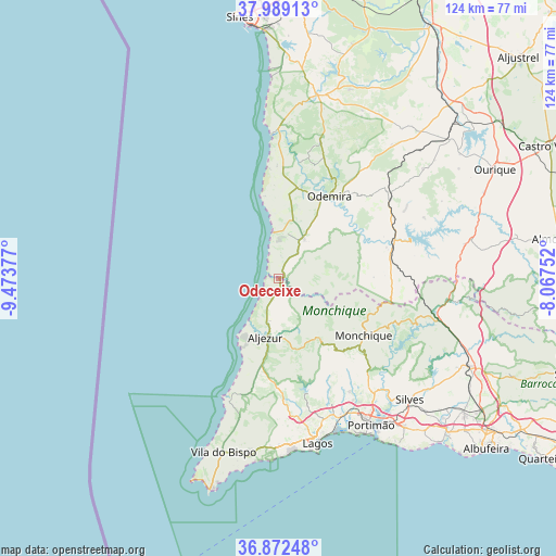
Odeceixe GPS coordinates[2]
37° 25' 58.404" North, 8° 46' 14.34" West
| Map corner | latitude | longitude |
|---|---|---|
| Upper-left | 37.98913°, | -9.47377° |
| Center: | 37.43289°, | -8.77065° |
| Lower-right: | 36.87248°, | -8.06752° |
| Map W x H: | 124.2×124.2 km | = 77.2×77.2mi |
| max Lat: | 42.11337° ⇑89.8% North |
| Odeceixe: | 37.43289° |
| min Lat: | ⇓10.2% South 32.6448° |
| min Long | Odeceixe | max Long |
| -31.17847° | -8.77065° | -6.27308° |
| W 33.4%⇐ | ⇒66.6% E |
Elevation
Elevation of Odeceixe is 22 m = 72 ft, and this is 155 m = 509 ft below average elevation for this country.
| Max E: |
1008 m = 3307 ft | 86.3% |
| Avg. | 177 m = 581 ft | |
| Odeceixe | 22 m = 72 ft | |
Min E: |
-128 m = -420 ft | 13.7% |
See also: Portugal elevation on elevation.city.
Geographical zone
Odeceixe is located in North temperate zone (between Tropic of Cancer and the Arctic Circle). Distance of this Northern Tropic circle is 1556.2 km =967 mi to South.| Distance of | km | miles | from Odeceixe |
|---|---|---|---|
| North Pole | 5844.9 | 3631.9 | to North |
| Arctic Circle | 3239 | 2012.6 | to North |
| Tropic Cancer | 1556.2 | 967 | to South |
| Equator | 4162.1 | 2586.2 | to South |


Nearby cities:
15 places around Odeceixe: (largest is in red/bold)
• Aljezur
13.1 km =8.1 mi,  191°
191°
• Almograve
25 km =15.5 mi,  355°
355°
• Alvor
37.2 km =23.1 mi,  154°
154°
• Barão de São João
32.7 km =20.3 mi,  181°
181°
• Bensafrim
31 km =19.3 mi,  174°
174°
• Boavista dos Pinheiros
18.9 km =11.7 mi,  29°
29°
• Marmelete
16.4 km =10.2 mi, 146°
• Mexilhoeira Grande
33.5 km =20.8 mi,  155°
155°
• Monchique
22.9 km =14.2 mi,  123°
123°
• Odemira
21.7 km =13.5 mi, 32°
• São Luis
32.8 km =20.4 mi,  16°
16°
• São Marcos da Serra
35.6 km =22.1 mi,  102°
102°
• São Teotónio
10.5 km =6.5 mi, 32°
• Vila Nova de Milfontes
32.4 km =20.1 mi, 358°
• Zambujeira do Mar
10.6 km =6.6 mi,  353°
353°
Sources, notices
• [Note1] Compared only with cities in Portugal existing in our database
• [Src1] Map data: © OpenStreetMap contributors (CC-BY-SA)
• [Src2] Other city data from geonames.org with taken over terms of usage.
• [Src3] Geographical zone / Annual Mean Temperature by Robert A. Rohde @ Wikipedia
