Bensafrim geodata
Bensafrim (Faro) is a populated place; located in Portugal in Europe/Lisbon (GMT+1) time zone. With population of 2,004 people, there are 644 cities with bigger population in this country. Compared to other cities in Portugal, 91.7% of cities are located further ↑North; 65% of cities are located further →East and 79.8% of cities have higher elevation than Bensafrim. Note1


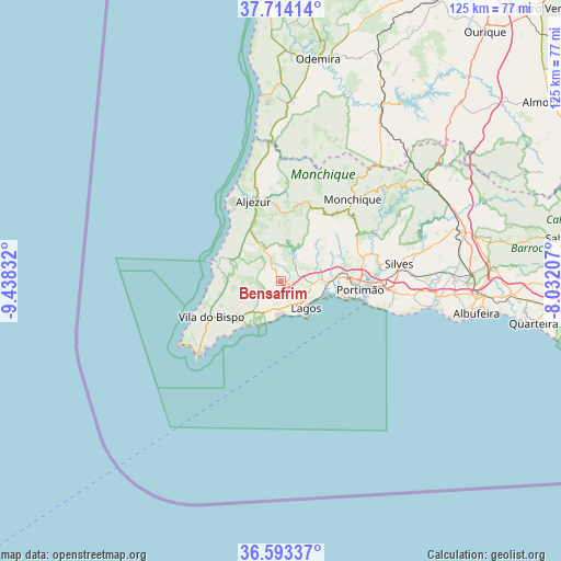
Bensafrim GPS coordinates[2]
37° 9' 20.988" North, 8° 44' 6.72" West
| Map corner | latitude | longitude |
|---|---|---|
| Upper-left | 37.71414°, | -9.43832° |
| Center: | 37.15583°, | -8.7352° |
| Lower-right: | 36.59337°, | -8.03207° |
| Map W x H: | 124.6×124.6 km | = 77.4×77.4mi |
| max Lat: | 42.11337° ⇑91.7% North |
| Bensafrim: | 37.15583° |
| min Lat: | ⇓8.3% South 32.6448° |
| min Long | Bensafrim | max Long |
| -31.17847° | -8.7352° | -6.27308° |
| W 35%⇐ | ⇒65% E |
Elevation
Elevation of Bensafrim is 33 m = 108 ft, and this is 144 m = 472 ft below average elevation for this country.
| Max E: |
1008 m = 3307 ft | 79.8% |
| Avg. | 177 m = 581 ft | |
| Bensafrim | 33 m = 108 ft | |
Min E: |
-128 m = -420 ft | 20.2% |
See also: Portugal elevation on elevation.city.
Geographical zone
Bensafrim is located in North temperate zone (between Tropic of Cancer and the Arctic Circle). Distance of this Northern Tropic circle is 1525.4 km =947.8 mi to South.| Distance of | km | miles | from Bensafrim |
|---|---|---|---|
| North Pole | 5875.7 | 3651 | to North |
| Arctic Circle | 3269.8 | 2031.8 | to North |
| Tropic Cancer | 1525.4 | 947.8 | to South |
| Equator | 4131.3 | 2567.1 | to South |


Nearby cities:
15 places around Bensafrim: (largest is in red/bold)
• Aljezur
18.9 km =11.7 mi,  341°
341°
• Alvor
13 km =8.1 mi,  102°
102°
• Barão de São João
4.2 km =2.6 mi,  243°
243°
• Carvoeiro
24.5 km =15.2 mi,  105°
105°
• Estômbar
22.2 km =13.8 mi,  92°
92°
• Ferragudo
19.5 km =12.1 mi, 100°
• Lagos
8.1 km =5 mi,  137°
137°
• Marmelete
18.2 km =11.3 mi,  19°
19°
• Mexilhoeira Grande
10.7 km =6.6 mi, 88°
• Monchique
24 km =14.9 mi,  41°
41°
• Parchal
19.4 km =12.1 mi, 95°
• Portimão
17.6 km =10.9 mi, 96°
• Sagres
24.7 km =15.3 mi,  228°
228°
• Senhora da Luz
7.6 km =4.7 mi,  174°
174°
• Vila do Bispo
17.6 km =10.9 mi, 242°
Sources, notices
• [Note1] Compared only with cities in Portugal existing in our database
• [Src1] Map data: © OpenStreetMap contributors (CC-BY-SA)
• [Src2] Other city data from geonames.org with taken over terms of usage.
• [Src3] Geographical zone / Annual Mean Temperature by Robert A. Rohde @ Wikipedia
