Monchique geodata
Monchique (Faro) is a seat of a second-order administrative division; located in Portugal in Europe/Lisbon (GMT+1) time zone. With population of 5,421 people, there are 397 cities with bigger population in this country. Compared to other cities in Portugal, 90% of cities are located further ↑North; 50.7% of cities are located further ←West and 88.9% of cities have lower elevation than Monchique. Note1


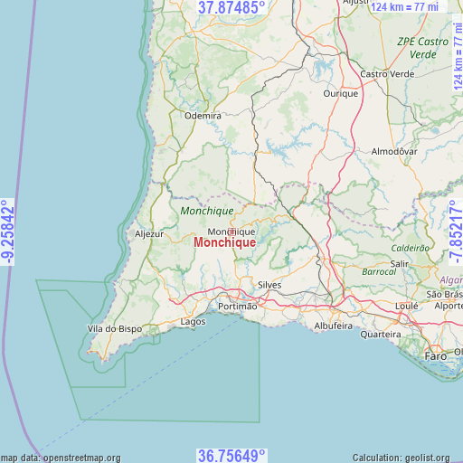
Monchique GPS coordinates[2]
37° 19' 3.9" North, 8° 33' 19.044" West
| Map corner | latitude | longitude |
|---|---|---|
| Upper-left | 37.87485°, | -9.25842° |
| Center: | 37.31775°, | -8.55529° |
| Lower-right: | 36.75649°, | -7.85217° |
| Map W x H: | 124.3×124.3 km | = 77.2×77.2mi |
| max Lat: | 42.11337° ⇑90% North |
| Monchique: | 37.31775° |
| min Lat: | ⇓10% South 32.6448° |
| min Long | Monchique | max Long |
| -31.17847° | -8.55529° | -6.27308° |
| W 50.7%⇐ | ⇒49.3% E |
Elevation
Elevation of Monchique is 439 m = 1440 ft, and this is 262 m = 860 ft above average elevation for this country.
| Max E: |
1008 m = 3307 ft | 11.1% |
| Monchique | 439 m 1440 ft | |
| Avg. | 177 m = 581 ft | |
Min E: |
-128 m = -420 ft | 88.9% |
See also: Portugal elevation on elevation.city.
Geographical zone
Monchique is located in North temperate zone (between Tropic of Cancer and the Arctic Circle). Distance of this Northern Tropic circle is 1543.4 km =959 mi to South.| Distance of | km | miles | from Monchique |
|---|---|---|---|
| North Pole | 5857.7 | 3639.8 | to North |
| Arctic Circle | 3251.8 | 2020.6 | to North |
| Tropic Cancer | 1543.4 | 959 | to South |
| Equator | 4149.3 | 2578.3 | to South |


Nearby cities:
15 places around Monchique: (largest is in red/bold)
• Aljezur
21.8 km =13.5 mi,  269°
269°
• Alvor
21.1 km =13.1 mi,  188°
188°
• Bensafrim
24 km =14.9 mi,  221°
221°
• Estômbar
20.1 km =12.5 mi,  161°
161°
• Ferragudo
21.7 km =13.5 mi,  171°
171°
• Lagoa
22.2 km =13.8 mi, 155°
• Marmelete
10 km =6.2 mi, 265°
• Mexilhoeira Grande
18.5 km =11.5 mi,  196°
196°
• Odeceixe
22.9 km =14.2 mi,  303°
303°
• Parchal
20.2 km =12.6 mi, 170°
• Porches
25.2 km =15.7 mi,  147°
147°
• Portimão
20 km =12.4 mi,  175°
175°
• Silves
17.7 km =11 mi,  144°
144°
• São Bartolomeu de Messines
24.7 km =15.3 mi,  105°
105°
• São Marcos da Serra
16.4 km =10.2 mi,  72°
72°
Sources, notices
• [Note1] Compared only with cities in Portugal existing in our database
• [Src1] Map data: © OpenStreetMap contributors (CC-BY-SA)
• [Src2] Other city data from geonames.org with taken over terms of usage.
• [Src3] Geographical zone / Annual Mean Temperature by Robert A. Rohde @ Wikipedia
