Marmelete geodata
Marmelete (Faro) is a populated place; located in Portugal in Europe/Lisbon (GMT+1) time zone. With population of 1,087 people, there are 738 cities with bigger population in this country. Compared to other cities in Portugal, 90.3% of cities are located further ↑North; 60.2% of cities are located further →East and 85.6% of cities have lower elevation than Marmelete. Note1


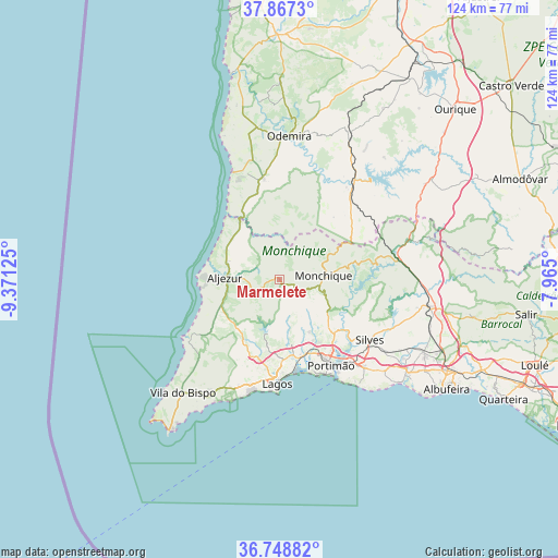
Marmelete GPS coordinates[2]
37° 18' 36.504" North, 8° 40' 5.268" West
| Map corner | latitude | longitude |
|---|---|---|
| Upper-left | 37.8673°, | -9.37125° |
| Center: | 37.31014°, | -8.66813° |
| Lower-right: | 36.74882°, | -7.965° |
| Map W x H: | 124.4×124.4 km | = 77.3×77.3mi |
| max Lat: | 42.11337° ⇑90.3% North |
| Marmelete: | 37.31014° |
| min Lat: | ⇓9.7% South 32.6448° |
| min Long | Marmelete | max Long |
| -31.17847° | -8.66813° | -6.27308° |
| W 39.8%⇐ | ⇒60.2% E |
Elevation
Elevation of Marmelete is 366 m = 1201 ft, and this is 189 m = 620 ft above average elevation for this country.
| Max E: |
1008 m = 3307 ft | 14.4% |
| Marmelete | 366 m 1201 ft | |
| Avg. | 177 m = 581 ft | |
Min E: |
-128 m = -420 ft | 85.6% |
See also: Portugal elevation on elevation.city.
Geographical zone
Marmelete is located in North temperate zone (between Tropic of Cancer and the Arctic Circle). Distance of this Northern Tropic circle is 1542.6 km =958.5 mi to South.| Distance of | km | miles | from Marmelete |
|---|---|---|---|
| North Pole | 5858.6 | 3640.4 | to North |
| Arctic Circle | 3252.7 | 2021.1 | to North |
| Tropic Cancer | 1542.6 | 958.5 | to South |
| Equator | 4148.5 | 2577.8 | to South |


Nearby cities:
15 places around Marmelete: (largest is in red/bold)
• Aljezur
11.8 km =7.3 mi,  273°
273°
• Alvor
21.1 km =13.1 mi,  161°
161°
• Barão de São João
21.4 km =13.3 mi,  206°
206°
• Bensafrim
18.2 km =11.3 mi,  199°
199°
• Estômbar
24.4 km =15.2 mi,  138°
138°
• Ferragudo
24.5 km =15.2 mi,  147°
147°
• Lagos
23.1 km =14.4 mi,  181°
181°
• Mexilhoeira Grande
17.5 km =10.9 mi, 164°
• Monchique
10 km =6.2 mi,  85°
85°
• Odeceixe
16.4 km =10.2 mi,  326°
326°
• Parchal
23.3 km =14.5 mi, 145°
• Portimão
22.3 km =13.9 mi, 148°
• Senhora da Luz
25.3 km =15.7 mi,  191°
191°
• Silves
24.4 km =15.2 mi,  123°
123°
• São Teotónio
22.8 km =14.2 mi,  351°
351°
Sources, notices
• [Note1] Compared only with cities in Portugal existing in our database
• [Src1] Map data: © OpenStreetMap contributors (CC-BY-SA)
• [Src2] Other city data from geonames.org with taken over terms of usage.
• [Src3] Geographical zone / Annual Mean Temperature by Robert A. Rohde @ Wikipedia
