Piribebuy geodata
Piribebuy (Cordillera) is a populated place; located in Paraguay in America/Asuncion (GMT-4) time zone. With population of 10,337 people, there are 33 cities with bigger population in this country. Compared to other cities in Paraguay, 51.2% of cities are located further ↓South; 64.2% of cities are located further →East and 82.7% of cities have lower elevation than Piribebuy. Note1


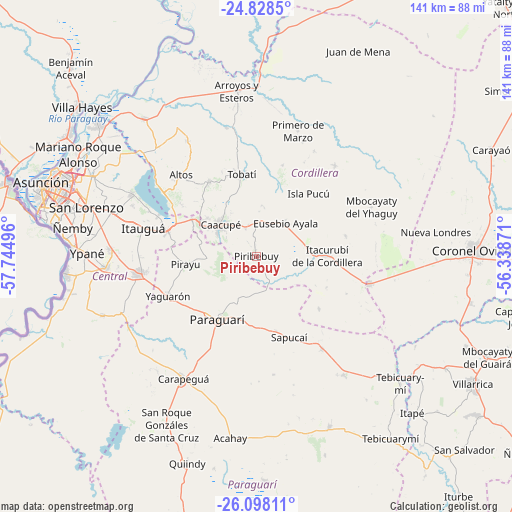
Piribebuy GPS coordinates[2]
25° 27' 53.928" South, 57° 2' 30.588" West
| Map corner | latitude | longitude |
|---|---|---|
| Upper-left | -24.8285°, | -57.74496° |
| Center: | -25.46498°, | -57.04183° |
| Lower-right: | -26.09811°, | -56.33871° |
| Map W x H: | 141.2×141.2 km | = 87.7×87.7mi |
| max Lat: | -19.91667° ⇑48.8% North |
| Piribebuy: | -25.46498° |
| min Lat: | ⇓51.2% South -27.38662° |
| min Long | Piribebuy | max Long |
| -60.78333° | -57.04183° | -54.30694° |
| W 35.8%⇐ | ⇒64.2% E |
Elevation
Elevation of Piribebuy is 253 m = 830 ft, and this is 83.3 m = 273 ft above average elevation for this country.
| Max E: |
658 m = 2159 ft | 17.3% |
| Piribebuy | 253 m 830 ft | |
| Avg. | 169.7 m = 557 ft | |
Min E: |
46 m = 151 ft | 82.7% |
See also: Paraguay elevation on elevation.city.
Geographical zone
Piribebuy is located in South temperate zone (between Tropic of Capricorn and the Antarctic Circle). Distance of this Southern Tropic circle is 225.5 km =140.1 mi to North.| Distance of | km | miles | from Piribebuy |
|---|---|---|---|
| Equator | 2831.4 | 1759.3 | to North |
| Tropic Capricorn | 225.5 | 140.1 | to North |
| Antarctic Circle | 4569.7 | 2839.5 | to South |
| South Pole | 7175.6 | 4458.7 | to South |


Nearby cities:
15 places around Piribebuy: (largest is in red/bold)
• Altos
31 km =19.3 mi,  316°
316°
• Atyrá
24.5 km =15.2 mi,  327°
327°
• Caacupé
13.4 km =8.3 mi,  311°
311°
• Eusebio Ayala
12.2 km =7.6 mi,  41°
41°
• Isla Pucú
22.5 km =14 mi, 39°
• Itacurubí de la Cordillera
18.9 km =11.7 mi,  88°
88°
• Paraguarí
20.3 km =12.6 mi,  211°
211°
• Pirayú
19.5 km =12.1 mi,  263°
263°
• San Bernardino
30.8 km =19.1 mi,  303°
303°
• Santa Elena
25.2 km =15.7 mi,  76°
76°
• Sapucaí
24.1 km =15 mi,  158°
158°
• Tobatí
23 km =14.3 mi,  349°
349°
• Valenzuela
22.5 km =14 mi,  130°
130°
• Yaguarón
26.5 km =16.5 mi,  246°
246°
• Ypacarai
25.6 km =15.9 mi,  284°
284°
Sources, notices
• [Note1] Compared only with cities in Paraguay existing in our database
• [Src1] Map data: © OpenStreetMap contributors (CC-BY-SA)
• [Src2] Other city data from geonames.org with taken over terms of usage.
• [Src3] Geographical zone / Annual Mean Temperature by Robert A. Rohde @ Wikipedia
