Caacupé geodata
Caacupé (Cordillera) is a seat of a first-order administrative division; located in Paraguay in America/Asuncion (GMT-4) time zone. With population of 21,696 people, there are 22 cities with bigger population in this country. Compared to other cities in Paraguay, 58% of cities are located further ↓South; 69.1% of cities are located further →East and 67.9% of cities have lower elevation than Caacupé. Note1


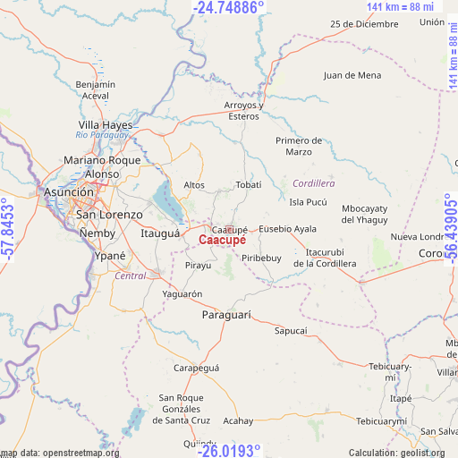
Caacupé GPS coordinates[2]
25° 23' 8.7" South, 57° 8' 31.812" West
| Map corner | latitude | longitude |
|---|---|---|
| Upper-left | -24.74886°, | -57.8453° |
| Center: | -25.38575°, | -57.14217° |
| Lower-right: | -26.0193°, | -56.43905° |
| Map W x H: | 141.3×141.3 km | = 87.8×87.8mi |
| max Lat: | -19.91667° ⇑42% North |
| Caacupé: | -25.38575° |
| min Lat: | ⇓58% South -27.38662° |
| min Long | Caacupé | max Long |
| -60.78333° | -57.14217° | -54.30694° |
| W 30.9%⇐ | ⇒69.1% E |
Elevation
Elevation of Caacupé is 180 m = 591 ft, and this is 10.3 m = 34 ft above average elevation for this country.
| Max E: |
658 m = 2159 ft | 32.1% |
| Caacupé | 180 m 591 ft | |
| Avg. | 169.7 m = 557 ft | |
Min E: |
46 m = 151 ft | 67.9% |
See also: Paraguay elevation on elevation.city.
Geographical zone
Caacupé is located in South temperate zone (between Tropic of Capricorn and the Antarctic Circle). Distance of this Southern Tropic circle is 216.7 km =134.7 mi to North.| Distance of | km | miles | from Caacupé |
|---|---|---|---|
| Equator | 2822.6 | 1753.9 | to North |
| Tropic Capricorn | 216.7 | 134.7 | to North |
| Antarctic Circle | 4578.5 | 2844.9 | to South |
| South Pole | 7184.4 | 4464.2 | to South |


Nearby cities:
15 places around Caacupé: (largest is in red/bold)
• Altos
17.7 km =11 mi,  320°
320°
• Areguá
25.7 km =16 mi,  288°
288°
• Atyrá
12.3 km =7.6 mi,  345°
345°
• Eusebio Ayala
18.2 km =11.3 mi,  88°
88°
• Isla Pucú
25.8 km =16 mi,  70°
70°
• Itacurubí de la Cordillera
30.2 km =18.8 mi,  106°
106°
• Itauguá
21.3 km =13.2 mi,  267°
267°
• Itá
25.9 km =16.1 mi,  240°
240°
• Paraguarí
26.1 km =16.2 mi,  181°
181°
• Pirayú
14.4 km =8.9 mi,  220°
220°
• Piribebuy
13.4 km =8.3 mi,  131°
131°
• San Bernardino
17.6 km =10.9 mi,  298°
298°
• Tobatí
15.1 km =9.4 mi,  23°
23°
• Yaguarón
24.1 km =15 mi, 215°
• Ypacarai
14.9 km =9.3 mi,  260°
260°
Sources, notices
• [Note1] Compared only with cities in Paraguay existing in our database
• [Src1] Map data: © OpenStreetMap contributors (CC-BY-SA)
• [Src2] Other city data from geonames.org with taken over terms of usage.
• [Src3] Geographical zone / Annual Mean Temperature by Robert A. Rohde @ Wikipedia
